
Navigation
Install the app
How to install the app on iOS
Follow along with the video below to see how to install our site as a web app on your home screen.
Note: This feature may not be available in some browsers.
More options
Style variation
You are using an out of date browser. It may not display this or other websites correctly.
You should upgrade or use an alternative browser.
You should upgrade or use an alternative browser.
PNW Flood Watch - Dec 8-12, 2025
- Thread starter Evan B
- Start date

Old406Kid
Legend
Just saw this....maybe not quite as bad but WOW!

Paige
Wishing I was fishing the Sauk
The bluff across from me got absolutely hammered.
Wednesday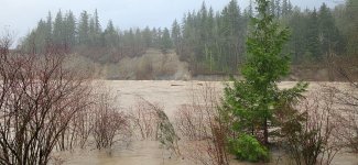
Friday morning.
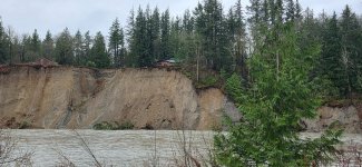
I have a bunch of videos of some of the slides, the biggest I missed but heard and got a small tsunami on Video!
I went and talked to the land owner above the bluff and sent them pics, many should know it.
It got really creepy last night hearing the slides crashing into the river after dark, the 1 at 12:45 am was the loudest!
Wednesday
Friday morning.
I have a bunch of videos of some of the slides, the biggest I missed but heard and got a small tsunami on Video!
I went and talked to the land owner above the bluff and sent them pics, many should know it.
It got really creepy last night hearing the slides crashing into the river after dark, the 1 at 12:45 am was the loudest!
I don't think that is true.I heard that Leavenworth is shut off on all access point. There are 4-5 primary roads that have fallen apart with the undermining.
I use this app while traveling rural areas. It has always been right. It puts all the state information in one place.
https://oss.weathershare.org/?clat=47.60249&clng=-120.88333&zoom=10

My wife left this morning to visit her sister in Leavenworth and all was good driving wise going over 90 and Blewett so at least that is an option.
Most of Leavenworth got power and water back again this morning (for those on a well).
Most of Leavenworth got power and water back again this morning (for those on a well).

Pink Nighty
Legend
Those old Lahar flows give me the absolute heebie jeebies. That all got laid down in a day. What we just went through is cascadia taking a shower. When she really wakes up she's an absolute terror.The bluff across from me got absolutely hammered.
Wednesday View attachment 174582
Friday morning.
View attachment 174583
I have a bunch of videos of some of the slides, the biggest I missed but heard and got a small tsunami on Video!
I went and talked to the land owner above the bluff and sent them pics, many should know it.
It got really creepy last night hearing the slides crashing into the river after dark, the 1 at 12:45 am was the loudest!
Paige
Wishing I was fishing the Sauk
Those old Lahar flows give me the absolute heebie jeebies. That all got laid down in a day. What we just went through is cascadia taking a shower. When she really wakes up she's an absolute terror.
Lahar from what?
This was the most movement I've seen combined from the last 13 yrs I've been here. They've been losing this bank since the 80s, very solid substrate compared to what is in the hills around Oso.
From what I've read, its just glacial deposits around here, and granite, lots of granite.

Okay - I truly admit I did not see this AR having this much IMPACT across our state or for that matter across our NW region. I believed it was just another annual winter event. Rivers rise, floods happen, flood waters go down, clean up a couple of landslides across roads and road closures and life goes on...
Man, was I wrong! It has been devastating to 100,000s and has a long lasting impact into the future. And yet another Pineapple Express is heading our way.
Not sure if local news and weather outlets had a clue, and if they did, they did not communicate clearly.
Not tying it to climate change, yet. El Nino/El Nina have been observed since early 1600s, maybe earlier. With current tools and knowledge, it should not be this much of a surprise. But it is...
Man, was I wrong! It has been devastating to 100,000s and has a long lasting impact into the future. And yet another Pineapple Express is heading our way.
Not sure if local news and weather outlets had a clue, and if they did, they did not communicate clearly.
Not tying it to climate change, yet. El Nino/El Nina have been observed since early 1600s, maybe earlier. With current tools and knowledge, it should not be this much of a surprise. But it is...

This might be helpful to some that are trying to get around in Skagit County.
 skagitcounty.maps.arcgis.com
It comes from this webpage:
 www.skagitcounty.net
Atlas
skagitcounty.maps.arcgis.com
It comes from this webpage:
Access Skagit County
www.skagitcounty.net

Interesting take. I feel like there was a good bit of warning that this was going to be a notable storm event. @Pink Nighty and I were texting about the crazy forecast back on the 3rd.Okay - I truly admit I did not see this AR having this much IMPACT across our state or for that matter across our NW region. I believed it was just another annual winter event. Rivers rise, floods happen, flood waters go down, clean up a couple of landslides across roads and road closures and life goes on...
Man, was I wrong! It has been devastating to 100,000s and has a long lasting impact into the future. And yet another Pineapple Express is heading our way.
Not sure if local news and weather outlets had a clue, and if they did, they did not communicate clearly.
Not tying it to climate change, yet. El Nino/El Nina have been observed since early 1600s, maybe earlier. With current tools and knowledge, it should not be this much of a surprise. But it is...

Every bit of information from every news/weather source I was looking at was calling for a record busting event with high potential for significant damage.Okay - I truly admit I did not see this AR having this much IMPACT across our state or for that matter across our NW region. I believed it was just another annual winter event. Rivers rise, floods happen, flood waters go down, clean up a couple of landslides across roads and road closures and life goes on...
Man, was I wrong! It has been devastating to 100,000s and has a long lasting impact into the future. And yet another Pineapple Express is heading our way.
Not sure if local news and weather outlets had a clue, and if they did, they did not communicate clearly.
Not tying it to climate change, yet. El Nino/El Nina have been observed since early 1600s, maybe earlier. With current tools and knowledge, it should not be this much of a surprise. But it is...
I was mostly looking at NWS.noaa.gov and NWAC.gov, and then the Chrome algorithm would feed me whatever random news sources. They all said the same thing.
What were your sources?
Perhaps the overall message was diluted (ahem) by the fact that we seem to be forecasting catastrophic “100 year” style events every few years nowadays, so maybe we’re getting numb to them?
Pink Nighty
Legend
It's my understanding (and that's been wrong before!) That the large, fine grained material bluffs along the sauk/skagit/stilly are lahar deposits from glacier peak. Thousand feet of mud coming screaming down the valleyLahar from what?
This was the most movement I've seen combined from the last 13 yrs I've been here. They've been losing this bank since the 80s, very solid substrate compared to what is in the hills around Oso.
From what I've read, its just glacial deposits around here, and granite, lots of granite.
The “100 year flood” term is sort of a misnomer, or at least not always fully understood. When people talk about the 100 year floodplain, what that usually means is that FEMA has mapped that area to have at least a 1% chance to be inundated with floodwaters in any given year. Those maps were generally produced before we started seeing the rate of climate change effects we are seeing now.Every bit of information from every news/weather source I was looking at was calling for a record busting event with high potential for significant damage.
I was mostly looking at NWS.noaa.gov and NWAC.gov, and then the Chrome algorithm would feed me whatever random news sources. They all said the same thing.
What were your sources?
Perhaps the overall message was diluted (ahem) by the fact that we seem to be forecasting catastrophic “100 year” style events every few years nowadays, so maybe we’re getting numb to them?
I read an article on this recently in Seattle Times I think. They probably explain it better than I but I don’t hide behind a paywall. Sometimes you also get what you paid for.

JayB
Life of the Party
Been paddling by that outside bend for ~20+ years and watching the progress. There's a very similar bank on the Middle Fork of the Snoqualmie with homes that are in a similar situation (although the burn rate seems much lower). Hopefully the owners of those properties have had ample time to come to terms with the inevitable.The bluff across from me got absolutely hammered.
Wednesday View attachment 174582
Friday morning.
View attachment 174583
I have a bunch of videos of some of the slides, the biggest I missed but heard and got a small tsunami on Video!
I went and talked to the land owner above the bluff and sent them pics, many should know it.
It got really creepy last night hearing the slides crashing into the river after dark, the 1 at 12:45 am was the loudest!
To Matt's point -
An example of how parameters such as (100-year-flood) has changed we need look no further than the North Fork Stillaguamish. There are USGS flow records going back nearly 100 years (started in 1929). According to FEMA flood frequencies for the NF were -
10-year 28,100 cfs
50-year 30,300 cfs
100-year 31,100 cfs
500-year 32,100 cfs
In the first 50 years of the flow records available for that USGS site the above looks pretty accurate. The largest flow event prior to 1980 was 30,600 (about what the recent event was). Since 1980 there has been 23 flood events larger than that FEMA 100-year flood.
Since the Puget Sound Chinook were listed as threatened under ESA the North Fork Stillaguamish has had 14 flood events greater than that FEMA's 500-year flood (32,100) level. Further 9 of those floods were greater 39,000 cfs - 1,000-year events? The largest event has been 55,100 cfs, the new 100-year flood frequency? I suspect this is significantly larger than any seen pre-1980.
While we can debate how large a role climate change may have played in that dramatic change in the NF hydrograph, I doubt we can deny that it has played at least some role. The role of those increased flows changes on the basin's ecosystem is for another discussion.
Curt
An example of how parameters such as (100-year-flood) has changed we need look no further than the North Fork Stillaguamish. There are USGS flow records going back nearly 100 years (started in 1929). According to FEMA flood frequencies for the NF were -
10-year 28,100 cfs
50-year 30,300 cfs
100-year 31,100 cfs
500-year 32,100 cfs
In the first 50 years of the flow records available for that USGS site the above looks pretty accurate. The largest flow event prior to 1980 was 30,600 (about what the recent event was). Since 1980 there has been 23 flood events larger than that FEMA 100-year flood.
Since the Puget Sound Chinook were listed as threatened under ESA the North Fork Stillaguamish has had 14 flood events greater than that FEMA's 500-year flood (32,100) level. Further 9 of those floods were greater 39,000 cfs - 1,000-year events? The largest event has been 55,100 cfs, the new 100-year flood frequency? I suspect this is significantly larger than any seen pre-1980.
While we can debate how large a role climate change may have played in that dramatic change in the NF hydrograph, I doubt we can deny that it has played at least some role. The role of those increased flows changes on the basin's ecosystem is for another discussion.
Curt
Last edited:
Paige
Wishing I was fishing the Sauk
It's my understanding (and that's been wrong before!) That the large, fine grained material bluffs along the sauk/skagit/stilly are lahar deposits from glacier peak. Thousand feet of mud coming screaming down the valley
This is on the Skykomish, so no Lahars.
Skagit/Sauk definitely have volcanic deposits from Glacier Peak.
Pink Nighty
Legend
Whoopsie! It's a dead ringer for the sauk, and what with your tag and all...This is on the Skykomish, so no Lahars.
Skagit/Sauk definitely have volcanic deposits from Glacier Peak.

i'm with MattB and the other guys on this. We had plenty of warnings something potentially big was coming. Honest i think it might have gotten under estimated.Okay - I truly admit I did not see this AR having this much IMPACT across our state or for that matter across our NW region. I believed it was just another annual winter event. Rivers rise, floods happen, flood waters go down, clean up a couple of landslides across roads and road closures and life goes on...
Man, was I wrong! It has been devastating to 100,000s and has a long lasting impact into the future. And yet another Pineapple Express is heading our way.
Not sure if local news and weather outlets had a clue, and if they did, they did not communicate clearly.
Not tying it to climate change, yet. El Nino/El Nina have been observed since early 1600s, maybe earlier. With current tools and knowledge, it should not be this much of a surprise. But it is...
What surprised me is that news of our flooding has become world wide news. European and Asian news agencies have picked up the stories and run with them. A foot plus of rain in 72 hours is a lot of rain, no matter where or who you are.
Now add in the Alberta Clipper thats just started to hit the northeastern US. Some places there havent seen that much snow or temps that low in over 2 decades. Hoping @Vagabond and @Canuck from Kansas and the rest of our east coast members are able to snuggle in at home and wait it out.