When I first got to Kansas, a fellow was driving me around, showing me places to live. He looked in the sky, saw the black clouds and stated, uh, oh, hail.... Growing up in Montreal, then years in Vancouver (BC that is), I thought, what's the big deal? Then I started noticing saucer sized dents on the hoods of cars - Hail ... Largest I saw during my time in Kansas was almost softball size - you do not want to be hit by one of those.A followup to today's severe weather setup in Oregon and Washington. This is a copy/paste from Dr. John Monteverdi (retired Meteorology prof) who's the administrator of a weather group I belong to. John (he's in his early 70's) and other long time forecasters and scientists cannot recall models reflecting severe hail potential like what is being forecast for this afternoon/evening. Folks that live in the Great Plains are used to this during the Spring - West Coasters, not so much. Once hail reaches golf ball size, it hurts when it hits you (don't ask how I know) and it damages cars, vegetation, roofs, etc. If you haven't already, set your smart phones to alert you when a severe or tornado warned thunderstorm is in the vicinity and pay attention to the sky.
John Monteverdi
Admin
This is a first in my experience. The NAM-3km is outlooking some values of CAPE that would be large even in the Great Plains. I don't know how realistic those values are for tomorrow afternoon along the I5 corridor from central Oregon to south of Olympia, but even half those values plus the shear induced upward pressure forces would give very large (golf ball) hail.
So I have never seen SPC stick a SIG HAIL on the West Coast. And that includes a 10% risk for hail 2" in diameter and larger.
But that's what the forecast soundings show (as well as a tornado risk). So kudos to someone at SPC who knows how to evaluate shear profiles and buoyancy structure and doesn't say "...but those don't happen on the West Coast..."
Stay safe folks!!!





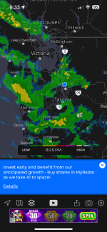

 . It takes 4 ingredients to make a severe thunderstorm: moisture, instability, a lifting mechanism, and shear (change of wind direction with height). The early afternoon clouds and rain showers gobbled up the instability that was needed to fire off the severe storms that were forecast later in the afternoon. Had that not occurred, the outcome might have been different. As a waterfowl biometrics guy once told me: all models are flawed, some models are useful.