Dry Falls

Stonedfish

Known Pluviophile
Forum Supporter
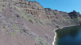
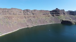
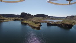
This popped up in a feed. Since many have fished Dry Falls and might be interested in this, I’ll post this in the lake forum.
SF

 
Wow it gives a great view of what was and is now. To think that the water flowed all the way to central Oregon is amazing. Dave
 
The Columbia Basin landscape carved by the Missoula Floods is amazing and special. J Harlan Bretz mapped it out by horseback and on foot. The geological community thought he was a lunatic, but eventually his theory became accepted. Early satellite imagery helped prove his theory. There is a book about him and his work on the floods that is a good read. https://www.amazon.com/Bretzs-Flood-Remarkable-Geologist-Greatest/dp/1570616310
 
Last edited:
This popped up in a feed. Since many have fished Dry Falls and might be interested in this, I’ll post this in the lake forum.
SF

Thanks for posting this B!
 
The scientific community has long held accepted dogma close to the vest and refuted all attempts to correct established theories. Bretz had to deal with all of that despite the obvious. Thankfully he lived long enough to be vindicated and his detractors shamed.

I feel like archaeology is in a similar mode right now trying to tell us that some of the prehistoric megaliths were all chipped out of solid rock-often granite-when some blocks were so obviously saw cut that the saw traces are still visible. The Pre History Guys on YouTube have the answer and it is: "We don't know..." Fanciful theorist like Graham Hancock have built a career around the "We don't know..." facts by filling in the missing gaps with imaginary bullshit none of which there is any actual evidence for.

Bretz faced the same thing but was one of the few that lived long enough to have his theory become fact.
 
The DNR info is super cool! I shared it in the Rocks thread but I think it was sorta buried there. More people here are into lakes than rocks I guess, which makes sense. :)

Bretz faced the same thing but was one of the few that lived long enough to have his theory become fact.
This is gonna sound nit-picky, but in a world where "facts" are somehow in dispute, I guess I feel obligated to say that Bretz's Ice Age Flood theory is widely accepted and there is a lot of evidence to support it, but unless we have a time machine we can't really call it a "fact."
 
This is gonna sound nit-picky, but in a world where "facts" are somehow in dispute, I guess I feel obligated to say that Bretz's Ice Age Flood theory is widely accepted and there is a lot of evidence to support it, but unless we have a time machine we can't really call it a "fact."
True. And there is growing evidence or suggestions of previous floods, which might mean that the Missoula floods furthered the erosion of E WA but aren't necessarily the sole cause.

The Columbia Basin landscape carved by the Missoula Floods is amazing and special. J Harlan Bretz mapped it out by horseback and on foot. The geological community thought he was a lunatic, but eventually his theory became accepted. Early satellite imagery helped prove his theory. There is a book about him and his work on the floods that is a good read. https://www.amazon.com/Bretzs-Flood-Remarkable-Geologist-Greatest/dp/1570616310

And to be more accurate, Bretz's flood theory was accepted only after others put Lake Missoula as the source. While the geological community at the time was just generally opposed to the cataclysmic nature of what he proposed, part of his battle was that he didn't have a source for the water, despite the existence of Lake Missoula already being well known at the time. Bretz himself spent most of his time fixated on the idea of an ice sheet previous to the most recent one. And while we now have good evidence of previous significant glaciation (and suggestions of potential previous flooding), the appeal of Lake Missoula is the massive volume of suddenly-available (liquid) water, something that takes unique circumstances in a model of gradual warming/retreat of the glaciation.

The challenge of studying an erosion-based landscape is that if there were multiple events, the more recent events tend to remove the evidence of previous events. This challenge is severely compounded if the most recent event(s) was also the largest event(s).
 
Last edited:
FWIW, getting water from montana to cataclysmically flood over dry falls takes some leaps in fluid dynamics and logic. The Montana-dry falls theory works like this:

Right around Brewster pool the okanogan lobe of ice blocked off the columbia, essentially creating lake roosevelt 15000 years ago. Water from Missoula comes crashing through rathdrum and mostly follows the Spokane river, plowing into ice age lake roosevelt. The lake swells and eventually oversteps at banks lake, creating the upper and lower grand coulee.

The problem with this two fold. Firstly, if lake roosevelt is in existence, why would water entering it in spokane not drain through the lower elevation notches along the columbia east of banks lake?

Secondly, how do you explain the water maintaining the velocity it needs to scour dry falls as it allegedly did after running into a lake. Nick zentners flood video shows essentially unimpeded, sediment laden flood waters crashing over dry falls. I dont think thats possible.

Even if dry falls is the best outlet for a flooding lake roosevelt, the lake would have taken out the velocity and sediment before it overtopped. Dont get me started on moses coulee, which has no direct connection to the columbia, much less montana.

The work being done on the pre-Missoula carving of coulees is fascinating. Missoula is a sexy story and played a big role, but the creation of eastern Washington's scablands is so much bigger than that.

 
This popped up in a feed. Since many have fished Dry Falls and might be interested in this, I’ll post this in the lake forum.
SF

DJI01484.jpegDJI01476.jpegDJI01477.jpeg
 
Back
Top