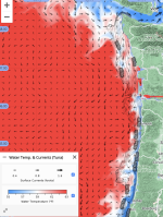
The sea surface temperatures have been quite anomalous this past week. When I checked yesterday, after
@Nick Clayton's post, I checked the temperatures on the
Tuna Fishers product offered by
NANOOS. There was some cool water (i.e., upwelling) along the Southern Oregon and Northern California coasts. But off Washington, there was warm surface water all the way to the coast (warm meaning in the lower 60's). Even today with a storm offshore and north-westerly winds, you can see how tight the warm surface water is to the Washington coast (with some upwelling off Vancouver Island and starting off the Washington coast).
View attachment 29378
This looks more like
downwelling, when winds from the south / southwest, push warm water toward the coast. WA often experiences downwelling in the winter; downwelling is associated with low productivity because it is pushing low-nutrient offshore water toward the coast. Our winter downwelling is one of the reasons that our salmon don't hang offshore in the winter but migrate up to Alaska where
other factors support productivity while Oregon and California salmonids find abundant food along the coast because of a longer upwelling window. [During upwelling, winds from the north push warm surface water offshore and draw up cooler, nutrient-rich water to the surface.].
Of course, this image is just showing surface temperatures from satellites. Holding salinity relatively constant (see this
diagram that expresses the relationship among salinity and temperature on density), you can have warm water (less dense) sitting over colder water (more dense) but you cannot have colder water sitting over warmer water.
Steve