
Navigation
Install the app
How to install the app on iOS
Follow along with the video below to see how to install our site as a web app on your home screen.
Note: This feature may not be available in some browsers.
More options
Style variation
You are using an out of date browser. It may not display this or other websites correctly.
You should upgrade or use an alternative browser.
You should upgrade or use an alternative browser.
PNW Flood Watch - Dec 8-12, 2025
- Thread starter Evan B
- Start date

We have some big fields up here where they spawn, their habitat pristine and unspoiled...
Run was late, but today they were full on bobbing around in pre spawn behavior.
Also very encouraging to witness the humpkins successfully navigating through all the new I-5 culverts. Once they just bobbed helplessly at the entrances with no hope of safe passage. Now they float through in seconds with hardly a scratch. Hats off to WSDOT!

They got all they up to Center Valley, where the habitat remains unspoiled, except for the Trustifarians from Port Townsend that make their pilgrimage to the pot shop, and then tend the organic farm fields adjacent to the spawning grounds. When the air is still, you can hear the dub step, and see the brightly colored tams through the haze of smoke.
Those don't all look wild to me. Looks like some hatchery genes got mixed into the gene pool. Probably why they are struggling to find appropriate migratory and rearing habitat.On the bright side, I'm seeing a ton of late season humpkins migrating out to the salt. Run looks strong.
View attachment 174343

At first glance, those appear to be of hatchery origin....probably best to catch and kill so as to not dilute the wild population.On the bright side, I'm seeing a ton of late season humpkins migrating out to the salt. Run looks strong.
View attachment 174343
awe crap, ya beat me to it!Those don't all look wild to me. Looks like some hatchery genes got mixed into the gene pool. Probably why they are struggling to find appropriate migratory and rearing habitat.

I personally only keep the wild humpkins that cut a bright orange.At first glance, those appear to be of hatchery origin....probably best to catch and kill so as to not dilute the wild population.

I was here when the record was set in 1990. If not for the dike breach below the forks it would have been much worse. We lived out on the flats in west Mount Vernon and drove over to the dike at the ball fields. There two rows of sandbags on top of the dike and one of them was under water. We turned around and could spot our house. Lucky for us there was a couple of barbed wire fences protecting us.Just caught up on the Skagit prediction updates. Looks like it could be pretty damn bad.

In 1995 we were on the hill where we live now in the Clear Lake area. Got trapped here for a day and watched the propane company launch a jet sled and go out into the fields and capture bobbing propane tanks around some of the farm houses. They dragged them over to the telephone poles along side the submerged Francis road and tie them off for later retrieval.
The bridge on hiway 9 over the East Fork Nookachamps Creek was blocked off. The water was up to the bottom of the bridge with high rolling waves flowing swiftly in the wrong direction and filling up the valley area around Beaver Lake.
In the 1990 flood that happened in November there were reports of Chums jumping in Clear Lake as the flood waters reached it for a day or so. A few weeks later as we walked through a field to get to the Stilly you could see Chums with their face peeled off from trying to hold in the current of muddy water. The entire river stank from all the dead chums hanging in the trees.
After this week there will be some new rivers to explore.

the_chemist
Life of the Party
Evacuation orders on the snohomish 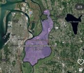
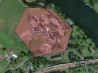

I'm an idiot. The 6 part got me I guess.2006 was brutal. The Snohomish punched through the French Slough levee and then flooded back UP the OLD Skykomish valley right to the edge of our Fryelands neighborhood in Monroe. Luckily, they built the whole neighborhood about 2' above the regular elevation.
My neighbor & I decided to duck hunt the flooded field to the west. We literally WALKED out from our houses. This is before the elementary school was there.
We both had a dozen decoys and our shotguns. I didn't bring the mutt since we knew he would have to float the whole time. I'm sure our other neighbors were not amused.
There were mice and spiders anywhere it was dry, which was pretty much just tall grass and fence posts. It was creepy. I don't remember shooting so no ducks for us.
Snohomish was a mess. Hopefully the levees and dikes hold this time!

The levee fail that we experienced in Snohomish & Monroe was in 95-96. We moved out of Monroe in 2003. Winter of 1995-1996 was a wet one!

Paige
Wishing I was fishing the Sauk
I'm an idiot. The 6 part got me I guess.
The levee fail that we experienced in Snohomish & Monroe was in 95-96. We moved out of Monroe in 2003. Winter of 1995-1996 was a wet one!
The 2006 was the record setter for the Sky at 129,000CFS, had hw2 closed at Bering with water on the road, water up to the road at eagle falls. Split rock was smooth water no wave at all, Index was evacuated with water over Galina road at the train trestle. water was 2 feet from the bridge over the Sultan, water was up to Bank of America and Wigal creek was backed up to hw 2 as well.
This one will get a few more feet but under 90k.
That is a shit ton of water coming down those two forks. I lived in a medium bank cabin between the forks and Index thru the 90s and went thru that decade of high water events. As I kid I was in Index the day after the 80 flood when the town lost half a dozen homes, the land they were on and the street with the homes on the opposite side becoming riverfront. The forks up there become monsters once the Gold bar gage gets around 100 cfs. Gonna be alot of nervous people in the valley tonight up high and then all day tomorrow and tomorrow night down low as that water pushes out.
I hope the new forecast is wrong, all the best to everyone living out on these systems and/or adjacent. All those dikes and levees will be maxed.
I hope the new forecast is wrong, all the best to everyone living out on these systems and/or adjacent. All those dikes and levees will be maxed.

Some old timer would probably reminisce about the days you could have walked dry-shod from one shore to the other on the backs of the orange beastsOn the bright side, I'm seeing a ton of late season humpkins migrating out to the salt. Run looks strong.
Hoping folks are dry and safe...

Yeah, I remember that year. Crazy times.I was here when the record was set in 1990.
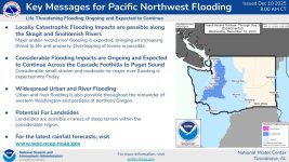

SeaRunner
Steelhead
The 2006 was the record setter for the Sky at 129,000CFS, had hw2 closed at Bering with water on the road, water up to the road at eagle falls. Split rock was smooth water no wave at all, Index was evacuated with water over Galina road at the train trestle. water was 2 feet from the bridge over the Sultan, water was up to Bank of America and Wigal creek was backed up to hw 2 as well.
This one will get a few more feet but under 90k.
Would be funny (not really) if Galena Road washed out again after all the work put in.