Wow, I just pulled up the water temperature graphic off the Washington coast from
NANOOS and there is NOTHING but warm water along the Washington and Oregon coasts.
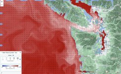
Normally, there is a band of cooler water along the coast due to
upwelling. This image below is from September 9th, 2022 and you can see the light blue band of cooler water along the coast and warmer water offshore. In a normal year, we have to plow our way 30ish miles offshore against the prevailing swell to reach the edge of the continental shelf where there is warm enough water for albacore.
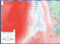
Upwelling occurs when winds from the northwest push warm, nutrient-poor surface waters away from the coast (due to the
Coriolis Effect) and cool, nutrient-rich waters rise to the surface to replace the warmer water offshore. But there is NOT sign of upwelling in the 2024 image.
This is great news for tuna fishers (and their fuel bills). But it may not not very good news for out-migrating salmon juveniles as they won't find much food to fuel their growth and migration to the Gulf of Alaska. Those nutrients are required by the phytoplankton, especially diatoms, that form the base of the oceanic food web. Without nutrients, no phytoplankton, no zooplankton (copepods, krill, etc.), no baitfish, starving salmon.
I checked with NOAA on where we are in the ENSO (
El Niño - Southern Oscillation vs La Niña) cycle and we are neutral conditions at present with a transition to La Niña starting about now through at least October. In general, El Niño disrupts / weakens upwelling along the west coast while La Niña strengthens coastal winds and enhances upwelling.
Steve