
Navigation
Install the app
How to install the app on iOS
Follow along with the video below to see how to install our site as a web app on your home screen.
Note: This feature may not be available in some browsers.
More options
Style variation
You are using an out of date browser. It may not display this or other websites correctly.
You should upgrade or use an alternative browser.
You should upgrade or use an alternative browser.
Rain
- Thread starter Stonedfish
- Start date


Oregon looks extremely wet today and tomorrow. Looks a bit wet in western Washington over the next 10 days as well.
Should have done the first spring lawn mowing yesterday. Oh well……
SF
Should have done the first spring lawn mowing yesterday. Oh well……
SF

Meh. It’ll be there when it stops raining.Should have done the first spring lawn mowing yesterday. Oh well……


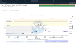
North Umpqua predicted to hit ~23' at Winchester today. I live on the river about 8mi upstream from the dam. We're heading to my daughter's place for an early dinner. Hope to be back and take pics during the zenith. I've been here 8 years and I don't think I've seen anything even up to 20'. My house is safe at this level and I moved everything down by the bank to high ground. Be interesting if it really takes the vertical spike this graph is projecting.

I saw stone flies and mayflies hatching last weekend on the river between my place and the dam. The trout I caught had fat bellies, looked and felt like they'd eaten a whole bag of gummies. Ya, they will be hugging rocks for a while.I went fishing on Tuesday. 03/11/25.
The Umpqua river was clean and clear, caught three small RBs.
It started raining on Wednesday and it is still raining and now the river is big and brown, and is gonna stay that way for many days to come.


FinLuver
Native Oregonian…1846
When Little River at Peel hits 17’ft or above is when the river is very high. I think the year was around ‘71, that it was the fifth highest all-time level. It was cool to see the dam flowing flat and the river level at Colliding Rivers was lapping underneath the old highway bridge.North Umpqua predicted to hit ~23' at Winchester today. I live on the river about 8mi upstream from the dam. We're heading to my daughter's place for an early dinner. Hope to be back and take pics during the zenith. I've been here 8 years and I don't think I've seen anything even up to 20'. My house is safe at this level and I moved everything down by the bank to high ground. Be interesting if it really takes the vertical spike this graph is projecting.
View attachment 145644
I’ve seen it very close to the back doors of the homes just upstream of the dam as well.
Love this river!!
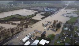
If I had a whale harpoon gun and a really strong winch I could make some decent money salvaging and selling the timber floating by my place. There's something awesome and ominous about a 30' Doug Fir log floating by at what must be 30mph, dead silent with branches sticking straight up.
FinLuver
Native Oregonian…1846
That is a sight, especially seeing going over the dam and watching the water tumble it.If I had a whale harpoon gun and a really strong winch I could make some decent money salvaging and selling the timber floating by my place. There's something awesome and ominous about a 30' Doug Fir log floating by at what must be 30mph, dead silent with branches sticking straight up.
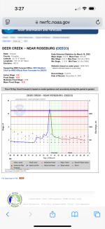
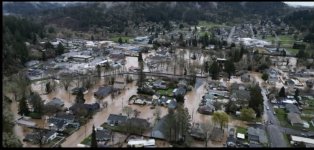
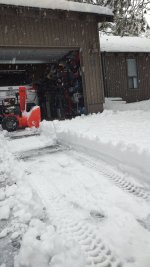
It’s sounding like Wednesday could be interesting weather wise after tomorrow’s warm temps.
SF
SF

I checked the flows on the Skagit, Sauk and Yakima! Blown out I'm sure.. drove by the Snoqualmie in Duvall and stopped at Valley House for a beer.. water is like chocolate milk, near flood stage and lots of logs floating by! With tomorrow's temps things may get interesting! Might have to resort to a lake on Wednesday, or more likely some sea run cutthroat trout fishing down south.. maybe just stay in and get stuff done!It’s sounding like Wednesday could be interesting weather wise after tomorrow’s warm temps.
SF

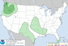
The Storm Prediction Center has been bullish on a marginal risk for severe thunderstorms over a broad area of Oregon and Washington on Wednesday. The CAM's (convective allowing models) are showing rotating storms/supercells rumbling through the area in the afternoon and early evening hours. One inch hail and gusty outflow winds are the primary threats right now but any time you have a rotating storm, a funnel cloud or brief tornado is possible.
Well, no plague of locusts, so I should be good! HA! Thanks for the info, seriously.. Looks like I'll be at home working on projects and maybe tying some flies! Cheers!The Storm Prediction Center has been bullish on a marginal risk for severe thunderstorms over a broad area of Oregon and Washington on Wednesday. The CAM's (convective allowing models) are showing rotating storms/supercells rumbling through the area in the afternoon and early evening hours. One inch hail and gusty outflow winds are the primary threats right now but any time you have a rotating storm, a funnel cloud or brief tornado is possible.
View attachment 146796
Always interesting! I check Cliff Mass when any big Western WA weather event hits or is about too! Who's building an ark?
 cliffmass.blogspot.com
Cliff Mass Weather Blog
This blog provides updated forecasts and comments on current weather or other topics
cliffmass.blogspot.com
SPC has now upgraded tomorrow’s outlook to a slight risk adding a higher risk for severe hail along with a possibility for a brief tornado - primarily along the I-5 corridor within the Willamette Valley and into Western Washington. New Day 2
If anyone see anything cool - take a pic and please post!
If anyone see anything cool - take a pic and please post!
A followup to today's severe weather setup in Oregon and Washington. This is a copy/paste from Dr. John Monteverdi (retired Meteorology prof) who's the administrator of a weather group I belong to. John (he's in his early 70's) and other long time forecasters and scientists cannot recall models reflecting severe hail potential like what is being forecast for this afternoon/evening. Folks that live in the Great Plains are used to this during the Spring - West Coasters, not so much. Once hail reaches golf ball size, it hurts when it hits you (don't ask how I know) and it damages cars, vegetation, roofs, etc. If you haven't already, set your smart phones to alert you when a severe or tornado warned thunderstorm is in the vicinity and pay attention to the sky.
John Monteverdi
Admin
This is a first in my experience. The NAM-3km is outlooking some values of CAPE that would be large even in the Great Plains. I don't know how realistic those values are for tomorrow afternoon along the I5 corridor from central Oregon to south of Olympia, but even half those values plus the shear induced upward pressure forces would give very large (golf ball) hail.
So I have never seen SPC stick a SIG HAIL on the West Coast. And that includes a 10% risk for hail 2" in diameter and larger.
But that's what the forecast soundings show (as well as a tornado risk). So kudos to someone at SPC who knows how to evaluate shear profiles and buoyancy structure and doesn't say "...but those don't happen on the West Coast..."
John Monteverdi
Admin
This is a first in my experience. The NAM-3km is outlooking some values of CAPE that would be large even in the Great Plains. I don't know how realistic those values are for tomorrow afternoon along the I5 corridor from central Oregon to south of Olympia, but even half those values plus the shear induced upward pressure forces would give very large (golf ball) hail.
So I have never seen SPC stick a SIG HAIL on the West Coast. And that includes a 10% risk for hail 2" in diameter and larger.
But that's what the forecast soundings show (as well as a tornado risk). So kudos to someone at SPC who knows how to evaluate shear profiles and buoyancy structure and doesn't say "...but those don't happen on the West Coast..."