El Nino ramping up

SurfnFish

Legend
Forum Supporter
Concensus is a very strong El Nino is ramping up, so increased temps, higher ocean temps, more rain and less snow. Last time we had a moderately strong El Nino measured 104" of rain on my coastal weather station by end of winter, and the mold had mold on it
Several good impact essays:

 
Concensus is a very strong El Nino is ramping up, so increased temps, higher ocean temps, more rain and less snow. Last time we had a moderately strong El Nino measured 104" of rain on my coastal weather station by end of winter, and the mold had mold on it
Several good impact essays:

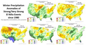
There are general expected weather impacts of El Nino vs. La Nina. This occurs mostly because the pressure differential at the equator of the Pacific Ocean impacts the position of the jet stream that pushes/guides storms across the Northern Pacific. Normally, El Nino conditions bring warmer, drier conditions to the PNW, and wetter, stormier conditions to California (and suppression of Atlantic hurricanes and augmentation of Pacific hurricanes). And La Nina conditions bring the reverse. While I was in gradual school at UCSB in the 80's, we experienced two strong El Ninos (82-83 and 86-87) that brought floods, massive storms, and disruptions of coastal upwelling that had huge impacts on kelp forests in Souther California. You can find information from the NWS climate prediction center here through on the temperature and rainfall tendencies expected through the end of December (and further out too by selecting a different lead period). [And see some historical data on coldest winter temperatures vs. El Nino / La Nina strength here. So, it wouldn't be a great winter to purchase a season ski pass, one would expect.
BUT these are general trends and some years can be wildly out of whack with these general weather predictions. For example, last summer was a La Nina which typically brings dry weather to California. But there were rains from one end of the state to the other breaking a long period of drought and filling their reservoirs.
Steve

 
There are general expected weather impacts of El Nino vs. La Nina. This occurs mostly because the pressure differential at the equator of the Pacific Ocean impacts the position of the jet stream that pushes/guides storms across the Northern Pacific. Normally, El Nino conditions bring warmer, drier conditions to the PNW, and wetter, stormier conditions to California (and suppression of Atlantic hurricanes and augmentation of Pacific hurricanes). And La Nina conditions bring the reverse. While I was in gradual school at UCSB in the 80's, we experienced two strong El Ninos (82-83 and 86-87) that brought floods, massive storms, and disruptions of coastal upwelling that had huge impacts on kelp forests in Souther California. You can find information from the NWS climate prediction center here through on the temperature and rainfall tendencies expected through the end of December (and further out too by selecting a different lead period). [And see some historical data on coldest winter temperatures vs. El Nino / La Nina strength here. So, it wouldn't be a great winter to purchase a season ski pass, one would expect.
BUT these are general trends and some years can be wildly out of whack with these general weather predictions. For example, last summer was a La Nina which typically brings dry weather to California. But there were rains from one end of the state to the other breaking a long period of drought and filling their reservoirs.
Steve
Are you trying to tell us weather can be unpredictable? ;)
 
There are general expected weather impacts of El Nino vs. La Nina. This occurs mostly because the pressure differential at the equator of the Pacific Ocean impacts the position of the jet stream that pushes/guides storms across the Northern Pacific. Normally, El Nino conditions bring warmer, drier conditions to the PNW, and wetter, stormier conditions to California (and suppression of Atlantic hurricanes and augmentation of Pacific hurricanes). And La Nina conditions bring the reverse. While I was in gradual school at UCSB in the 80's, we experienced two strong El Ninos (82-83 and 86-87) that brought floods, massive storms, and disruptions of coastal upwelling that had huge impacts on kelp forests in Souther California. You can find information from the NWS climate prediction center here through on the temperature and rainfall tendencies expected through the end of December (and further out too by selecting a different lead period). [And see some historical data on coldest winter temperatures vs. El Nino / La Nina strength here. So, it wouldn't be a great winter to purchase a season ski pass, one would expect.
BUT these are general trends and some years can be wildly out of whack with these general weather predictions. For example, last summer was a La Nina which typically brings dry weather to California. But there were rains from one end of the state to the other breaking a long period of drought and filling their reservoirs.
Steve
The pressure differentials are a result of MJO/ENSO variance, not the cause.
MJO/ENSO Discussion
The Madden Julian Oscillation (MJO) is a periodic weather cycle that tracks east along the equator circumnavigating the globe. It is characterized in it's Inactive Phase by enhanced trade winds and dry weather over the part of the equator it is in control of, and in it's Active Phase by slackening if not an outright reversing trade winds while enhancing precipitation. The oscillation occurs in roughly 20-30 day cycles (Inactive for 20-30 days, then Active for 20-30 days) over any single location on the planet, though most noticeable in the Pacific. During the Active Phase in the Pacific the MJO tends to support the formation of stronger and longer lasting gales resulting in enhanced potential for the formation of swell producing storms. Prolonged and consecutive Active MJO Phases in the Pacific help support the formation of El Nino. During the Inactive Phase the jet stream tends to split resulting in high pressure and less potential for swell producing storm development. Wind anomalies in the Kelvin Wave Generation Area (KWGA) are key for understanding what Phase the MJO is in over the Pacific. The KWGA is located on the equator from 135E-170W and 5 degs north and south (or on the equator from New Guinea east to the dateline). West wind anomalies in the KWGA suggest the Active Phase of the MJO in the Pacific, and east anomalies suggests the Inactive Phase. In turn the Active Phase strengthens and the Inactive Phase weakens the jetstream, which in turn enhances or dampens storm production respectively in the Pacific.And the El Nino/La Nino cycle (collectively know as ENSO - El Nino Southern Oscillation) is a less frequent (about once every 7 years) but more impactful cycle that affects world wide weather. Specifically, strong El Nino events promote storm production in the Pacific while La Nina events suppress storm production. These therefore have a significant impact on the production of swell and surf. The paragraphs below analyze the state of the MJO and ENSO in the Pacific and provide forecasts for upcoming activity (or inactivity depending on the state and interaction of these two oscillations).
 
yea, the 15/16 winter was the referenced drencher, #18 out to the coast closed due for two days due to the Salmon River rising 14' and overflowing it's banks in Otis and across the road.
My friend Mark who runs Stormsurf posited last year that El Nino/La Nina events will become increasingly unpredictable as the input drivers create more local variance.
HIs latest deep dive on El Nino found by scrolling below his weekly the surf forecast

 
Winter 2014-2015 was a moderately strong El Niño and the summer of 2015 ended up being brutal because there was almost no snowpack…but it also seems to have sort of been the start of an apparent trend toward lower low streamflows.
 
when El Nino warm wet fronts arrive they can rain like hell on the coast and valley, but when they reach the mountains and lift, the dry adiabatic lapse rate/DALR nevers drops the air mass temp low enough to convert the rain into snow, the DALR being a loss of 5.5 degree Farenheit per 1000' of altitude gain.
 
Back
Top