Can confirm.... plus... Geese......
So many geese! Plus three hundred widgeon that show up for the winter these days. But I refuse to blame the shovelers, cos they’re cute.
Can confirm.... plus... Geese......
I don't know anything about that Diamond lake but a TMDL (which is generally issued under the federal Clean Water Act, and implemented directly by EPA in some states, or by EPA delegated water quality programs like Oregon's DEQ or Washington's Department of Ecology) occurs when monitoring indicates that a water body doesn't meet sufficient quality for its intended uses. The TMDL is developed by determining Waste Load Allocations (WLA) for specific pollutants that would allow the water body to meet those uses. TMDLs and their associated WLAs are really only enforceable upon 'point-source' pollution dischargers like industry and municipalities, and don't have significant regulatory power over 'non-point source' pollution that originates from septic drainfields or diffuse agricultural practices.Pardon the somewhat of a post topic drift.
That "Gem of a Lake in Southwest Oregon"(Diamond) has been experiencing a cyanobacteria bloom on a year round basis for at least 7 years.
The below cut and paste is part of a 2017 email correspondence I had with Oregon regulatory agencies regarding this issue.
"DEQ issued a Total Maximum Daily Load (TMDL) for the lake that was approved by EPA in 2007 to guide water quality improvements............Currently, DEQ does not have a full-time staff person assigned to the Umpqua Basin and has not allocated resources to monitoring at the lake for several years. We understand other agencies also face budget challenges that prevent dedicating additional resources for monitoring, analysis or management actions. DEQ identified re-engagement in Diamond Lake management as a priority for the Umpqua Basin, but have not identified a funding source for that effort since our federal grant funds were reduced. Consequently, I can’t offer any positive news in terms of concrete action."
We used to hunt a lake and some ponds off Frenchman Wasteway south of George. Usually float tubes, but we also used a canoe to set dekes one year.Excellent example!
Perhaps the drawdown hastened its demise, but that lake is succumbing to the natural process of succession, in which it slowly transitions from aquatic to terrestrial vegetation.

I support and believe and push this conspiracy!I can't remember if I mentioned this dying lake on this site or WFF; a mile or so SSW of Coulee City sits Castle Lake, or what if anything, remains of this once fun trout fishery. Castle Lake's access was sketchy: a rebar ladder was (is?) set into holes drilled into vertical columnar basalt provided access from the coulee rim to the top of talus slope, then that trickly hike on the talus (carrying a donut float tube) slope to the lake edge. Castle Lake is where I first experienced a water boatmen "hatch" (so much fun!), on another trip to the lake a friend of mine harvested two fat rainbows that had these hard bulges in their stomachs (big crawfish). It was (WAS) a fun lake for a younger man to hike into and fish.
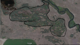
@Engee and I hiked into this lake about 2005-06, it was much smaller than the lake that Darc Knobel showed me in 1986 when I moved to the Basin. Here's an image from Google Earth - worth the hike to view the magesty of Glacial Lake Missoula flood events but that's maybe what Krusty means it will take to restore this lake to a "live" lake.
View attachment 93908
Conspiracy theory: blame the lakes death (eutrophication?) on the Banks Lake drawdown a decade or more ago?