Today I headed East at 4:30AM for a 6AM start on a river I’ve never fished before. Like the day after 9/11, America was never the same. So it was for the Yellowstone River on June 13, 2022. The immovable moved as the river witnessed historic flooding in Paradise Valley. Having fished the old Yellowstone for many years, it wasn’t unusual to see minor changes in the stream bed and shoreline each season after run-off. Some years changes were more dramatic than others, but the 2022 Montana floods were nothing if not epic. Many of my fly shop friends had warned me that the river had changed quite a bit since the flooding. Guides who know the river like the back of their hand were experiencing a new river everywhere they floated.


Flows at my put-in point were still up a bit above ~4200 CFS and the river still had a bit of a color. Visibility was about 3’. Fishing turned out OK, but the real purpose of the trip was to witness whatever changes the river might have experienced in this section during the flood. The first big change was at the put-in. The eastern shoreline of the river had moved at least 50 yards west with the deposit of massive amounts of cobble and sand. When the river reaches normal summer and winter flows, it will be a long drag to the river’s edge. The debris pile alongside the put-in was a clue as to how high the flow reached during the flood. What was once a very wide pool with shallow edges had narrowed considerably and a rather sharp, deep edge along the eastern shoreline.


The western shoreline had been aggressively cut and several perennial log jams had been swept away. The next long pool upstream had historically demonstrated a steady mid-stream flow with shallow edges that allowed long casts into the deepest parts of the pool. That's now gone as the pool deepen across the width of the river and several long gravel islands formed at the head of the pool. The eastern shoreline deepened considerably and accumulated a lot of log jams. It will be decent brown trout holding water once things settle out. Associated with this pool was a side channel clearly separated from the main pool by an underwater gravel bar. It is now gone, and the main river built up a long gravel island which is breached in several places by tongues of water pouring into the deepened side channel.


This is all freshly deposited rock and sand along the mouth of the side channel. The previous shoreline was very close to the willow line.

One of the things my fly shop friends warned me of was the sand and silt now pretty much found everywhere along the river. This image shows masses of freshly deposited silt at the mouth of the side channel. The old shoreline was approximately where the dry sand is. Everywhere I waded, I was stirring up silt and mucking up the water. It's going to take several normal run-off seasons to clear off the massive amounts of silt that has been deposited along the river shorelines, although it should start to revegetate by next season.
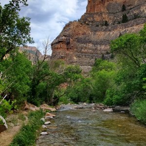
My favorite side channel went through the flood unscared although it may have been deepened a bit. The massive cottonwood stump along the bank is a testament to the strength of the flood. It will be there a while.
Once flows reach normal summer levels 2500-3500 CFS, we'll see in more detail some of the significant changes in the river channel. Next Spring, when flows can fall below 1000 CFS, it will be a new river once again.