DoesItFloat
Life of the Party
Umm, yeah, no.
I get the excitement behind whitewater kayaking, but this doesn't even look slightly fun.

Follow along with the video below to see how to install our site as a web app on your home screen.
Note: This feature may not be available in some browsers.
Umm, yeah, no.

And if they get in trouble, they are impacting resources that are stretched thin.I get the excitement behind whitewater kayaking, but this doesn't even look slightly fun.

<inappropriate and/or misinterpreted comment deleted>And if they get in trouble, they are impacting resources that are stretched thin.


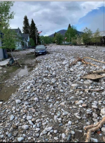
That is just brutal.Main street in Red Lodge today.
View attachment 18391


A different Rock Creek and it's branches.When a river gets it's dander up, it sure can move every thing in it's path. I wonder if there is any Gold in all that new sand in town. What skinny water flows past or through that town. I never ever made it to that part of the state.

This looks like a normal street in my home town…and it didn’t take a natural disaster to let it get that way. Just Say’n.Main street in Red Lodge today.
View attachment 18391


I think they use the term “normal” high water mark, which makes it a little squishy. But yes, F them.This flood has now redefined high water mark and I'm curious how this will affect our stream access laws. One in particular will be the wade section on the Upper Madison.
The land owners below Three Dollar Bridge on the south side of the river have signs posted that if you are standing in the vegetation, you are trespassing. Some are kind of dicks about it. I've never gotten any confirmation by the game warden or the fly shops. Most will simply tell you keep your feet wet just to be safe.
With the higher flows, we now we have water burping over into the vegetation. Feels like those banks are now fair game and I'd love to tell one of those pricks to fuck off. They have been active in trying to shut down floating in that section in an attempt to control access for themselves.
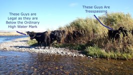
Just to give you a better idea, here is a photo of the type bank I'm referring to.


Umm, yeah, no.

This flood has now redefined high water mark and I'm curious how this will affect our stream access laws. One in particular will be the wade section on the Upper Madison.
The land owners below Three Dollar Bridge on the south side of the river have signs posted that if you are standing in the vegetation, you are trespassing. Some are kind of dicks about it. I've never gotten any confirmation by the game warden or the fly shops. Most will simply tell you keep your feet wet just to be safe.
With the higher flows, we now we have water burping over into the vegetation. Feels like those banks are now fair game and I'd love to tell one of those pricks to fuck off. They have been active in trying to shut down floating in that section in an attempt to control access for themselves.
Just to give you a better idea, here is a photo of the type bank I'm referring to.
If they're trying to shut down floating, then yes, F them.
If they just don't want you setting foot on their land without permission, then I get that.
They paid for it (dearly), they pay taxes on it, and some folks leave trash and trash the vegetation.


From the MT FWP brochure on the Montana Stream Access Law:This flood has now redefined high water mark and I'm curious how this will affect our stream access laws. One in particular will be the wade section on the Upper Madison.
The land owners below Three Dollar Bridge on the south side of the river have signs posted that if you are standing in the vegetation, you are trespassing. Some are kind of dicks about it. I've never gotten any confirmation by the game warden or the fly shops. Most will simply tell you keep your feet wet just to be safe.
With the higher flows, we now we have water burping over into the vegetation. Feels like those banks are now fair game and I'd love to tell one of those pricks to fuck off. They have been active in trying to shut down floating in that section in an attempt to control access for themselves.
Just to give you a better idea, here is a photo of the type bank I'm referring to.

The Dick spinner would just compliment the truck balls they have on there jacked up trucks!From the MT FWP brochure on the Montana Stream Access Law:
"Ordinary high-water mark means the line that water impresses on land by covering it for sufficient time to cause different characteristics below the line, such as deprivation of the soil of substantially all its terrestrial vegetation and destruction of its value for agricultural vegetation. Flood plains next to streams are considered to be above the ordinary high-water mark, and are not open for recreation without permission."
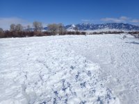
@swimmy raised a good point. In all probability, the ordinary high-water will have changed in places. but just because a section of bank flooded doesn't necessarily mean it changes the "ordinary high-water mark". I tried to go through some photos I have on the Madison (different section) to illustrate the reality of what's to come.
View attachment 18431
The entire area in the following image floods (ice jams) every winter. All the vegetation is covered (flooded) with ice.
View attachment 18432
Where there is little or no vegetation adjacent to the river defines the "ordinary high water mark". Areas above that, even though they might flood at times is not.
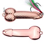
Well, as to the phalli landowners along the upper Madison who try and abuse the Montana Stream Access Law through extreme interpretations of the law, send them one of these with a copy of the law. I am sure they will appreciate it.
View attachment 18433