El Nino is definitely on its way

SurfnFish

Legend
Forum Supporter
Latest from my friend Mark at Stormsurf:

Major El Nino Setting Up with Massive Westerly Wind Burst In Control and Becoming Coupled
Large Kelvin Wave #3 Erupting in Ecuador - Another Large Kevin Wave #4 Developing

In Nov '25 westerly anomalies associated with Active Phase of the MJO #1 took root producing a Kelvin Wave pushing warm subsurface waters east. In early January strong Active MJO #2 started producing a second WWB in the far West Pacific producing Kelvin Wave #2. Kelvin Waves #1 & #2 started impacted Ecuador in March. And in late Feb Active Phase #3 developed with strong west anomalies holding into 4/15. Large Kelvin Wave #3 is erupting over Ecuador. And a Westerly Wind Burst started over the KWGA 5/17 and continue today likely setting up Kelvin Wave #4. Lower pressure is building over the dateline and high pressure is building over the Maritime Continent. A full turn to El Nino is setting up over the equatorial Pacific.
 
Here's the latest from my weather group by Jan Null (one of the site administrators and certified consulting meteorologist):
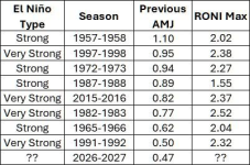
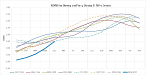
The latest 3-month RONI (Relative Oceanic Niño Index) for April-May-June is at +0.47, just shy of the threshold for a weak El Niño. But looking at the sharp upward trajectory (and latest monthly values) of the current event, it is obvious we are headed much higher.
And comparing it to the 7 previous Strong and Very Strong El Niños, this year is starting lower than any of the previous events at this point in the year, and the only one that transitioned from La Niña. But what does all this mean in terms of the developing El Niño and more so on what the actual impacts will be? Stay tuned.

1783431618246.png

1783431647761.png
 
I wonder when the carp guys are going to stop fucking around and start dressing like real fishermen.

1783462269877.jpeg

Note: While searching for this image I came across a fellow wearing the Borat swimsuit, holding a large Koi, with a tiara party hat on his head. Out of respect for the board I have made the decision not to post it. If you find that kind of thing funny (I did) here's the link. Might be NSFW
 
Need to get a MULITIA going to fight the oncoming EL NINIO!! worked for those guys in Florida!! They got a Big MULITIA together and all fired into the HURRICANE!!!!!! The hurricane changed course it didn't DARE continue on in the path of these guys!!!!!

Big COMMUNITY ACTIONS are the way 2 go when it comes to these various el nino-based situations.
 
Need to get a MULITIA going to fight the oncoming EL NINIO!! worked for those guys in Florida!! They got a Big MULITIA together and all fired into the HURRICANE!!!!!! The hurricane changed course it didn't DARE continue on in the path of these guys!!!!!

Big COMMUNITY ACTIONS are the way 2 go when it comes to these various el nino-based situations.
Travers and El Niño. Just a couple forces of nature blowing immense amounts of hot air.
 
The primary concern about this Super El Nino which differentiates it from past similar events is that current ocean and atmosphere temps recordings are at a record high = far more 'loaded' latent heat on tap, whereas past Super El Ninos began with lower ocean/air starting temps.
It will as always come down to the southern jet stream. Will it stay pinned over lower CA, soaking them, while a low moisture high pressure system locks down over the PNW, typical in most El Nino events?
Or does this El Nino become so strong it breaks up the southern jet enough that it will send a low pressure track north carrying weather systems with it?
Considering the drought conditions of both states, let us fervently hope for the latter.
 
I have seen some discussion about a Polar Vortex this upcoming winter due to the super El Nino. Too scientific for me to understand. Is it a concern also?
 
I have seen some discussion about a Polar Vortex this upcoming winter due to the super El Nino. Too scientific for me to understand. Is it a concern also?
A 'super' El Nino actually breaks down a Polar Vortex , which can allow strong winter weather systems to migrate further south with increased snowfall for Canada and the northern US.
Weather is the planet simply trying to reach atmospheric pressure balance, accomplished via the Pressure Gradient Force in which air/wind from high pressure areas will flow into low pressure areas.
What complicates reaching balance is the significant variation in planetary regional temperature zones, the Coriolis differential between the northern and southern hemispheres pushing warm and cold ocean currents in opposite directions, and the thousands of micro climates across the globe generating localized high/low pressure zones.
The most significant driver in weather, however, is heat load which = energy.
To put that into perspective a one degree centigrade increase in the planets oceans = 1,000 x the total annual energy output of the entire human population.
Projected temp rise of our oceans by end of century? Three degrees centigrade.
 
Last edited:
Back
Top