New To Me Stream Flow Chart

'well, Charlie, about those Cholesterol levels...couldn't actually take them with a blood draw so we used a dipstick...lol
 
I notice that site only has some of the data for our region. The three that I use in out area in SE WA are:
https://apps.ecology.wa.gov/continuousflowandwq/?sta=32A100
http://wwbwc.org/monitoring/surfacewater.html
There are others also, but those give me the picture.
 
I notice that site only has some of the data for our region.
I noticed that too and wondered if it's still in the development stage.
I also wonder if you join and log in if there's more info available?
 
Last edited:
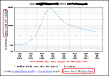
The USGS site has the "Water Alert" feature. It's probably meant for landowners adjacent to streams for warning of flood stage, but allows me to subscribe to daily email notifications when a stream is between X cfs and XX cfs. I know the max CFS that I can safely wade and find fish for the streams I like to fish. I enter the upper and lower cfs levels and subscribe for several streams then get notified by email as soon as they drop into shape.
 
The USGS site has the "Water Alert" feature. It's probably meant for landowners adjacent to streams for warning of flood stage, but allows me to subscribe to daily email notifications when a stream is between X cfs and XX cfs. I know the max CFS that I can safely wade and find fish for the streams I like to fish. I enter the upper and lower cfs levels and subscribe for several streams then get notified by email as soon as they drop into shape.
Good idea. I don’t think it would help my (non-fishing) productivity one single bit, though!
 
The USGS site has the "Water Alert" feature. It's probably meant for landowners adjacent to streams for warning of flood stage, but allows me to subscribe to daily email notifications when a stream is between X cfs and XX cfs. I know the max CFS that I can safely wade and find fish for the streams I like to fish. I enter the upper and lower cfs levels and subscribe for several streams then get notified by email as soon as they drop into shape.

Here is where to find the WaterAlert feature link
1646502006577.png

Details on the USGS "WaterAlert" page:
"Real-time data from USGS gages are transmitted via satellite or other telemetry to USGS offices at various intervals; in most cases, 1 to 4 times per hour. Emergency transmissions, such as during floods, may be more frequent. Notifications will be based on the data received at these site-dependent intervals."
"about this" hover link
1646500434496.png
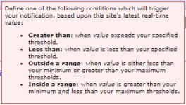
CFS levels fluctuate up and down for each stream so right or wrong I use the "Inside a range" function
1646500131398.png
I know the highest cfs level for safe wading and finding fish to enter. I guess on a level for the lower cfs that I believe will indicate the level will remain below my max cfs yet will get at least one email when the water is between those two levels on a given day. I also want the lower cfs number high enough that I don't get email for more than one or two days.

Keeping track of cfs in a fishing log helps me optimize the levels.
 
Last edited:
The Ecology Department In Washington State. Works, I used to use that one on skinny water that isn't listed in the USGS site.
 
I am a real nerd at trying to predict what conditions will be like before an outing.

Bringing over a post I made on the other site...
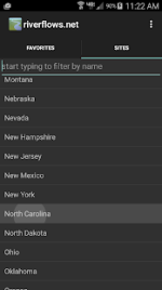
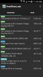
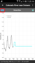
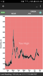
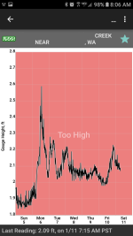
There are good apps for phones and tablets too. I use the Android "River Flows" app. It accesses USGS, the NOAA Advanced Hydrologic Prediction Service (AHPS) predictive, and other data sources. The 2nd pic shows a tab with an abbreviated list of streams the user can save as "Favorites" The 3rd pic shows a gauge site with data from AHPS and saved as a Favorite; indicated by the blue star, that is handy for looking ahead a few days to plan trips.
1646509605973.png 1646509536261.png 1646509972336.png
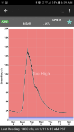
I have researched water levels on the USGS site for streams I like to fish during time periods that my records show I've had good success and created a table for the best levels of my very favorite streams. I discovered the app also has the ability to enter CFS levels for "Too Low-Low-Medium-High-Too High" parameters for each stream saved as a "Favorite" and entered the levels from my table and records.
1646509810145.png1646509828072.png1646509851611.png
Again, keeping track of cfs in a fishing log helps me optimize the levels.
 
Last edited:
The Ecology Department In Washington State. Works, I used to use that one on skinny water that isn't listed in the USGS site.
I don't know if the data at
is exclusive to WA DOE but the number of monitoring sites shown is pretty sparse in the regions where I fish blue lines.
Maybe budget cuts has reduced the monitoring sites from your days in WA.
 
When I was fishing in Washington I knew when the water levels were prime for catching fish. I learned how to read the charts.
 
Maybe budget cuts has reduced the monitoring sites from your days in WA.
When I was fishing in Washington I knew when the water levels were prime for catching fish. I learned how to read the charts.
In that link I included for the DOE Freshwater DataStream website there are only 69 DOE streamflow monitoring sites left in the whole state!
When fishing a stream without a reporting gauge I do use USGS and AHPS sites from adjacent drainages as a guide, and enter those readings in my records when updating my fishing log.
 
Back
Top