
A bit more - I'd missed four years of fishing the lakes in the Thompson/Nicola region. Two after the border being closed and the year before the border closure because my wife and I chose to go to Japan and babysit our grandson while his mother was having a second child (grandkids are the best, better than fishing trips). This was my second trip across the border since Canada began allowing tourist crossings. The first crossing, last October, included a second PCR test which was monitored via telehphone. This time, no PCR test less than 72 hours before crossing; updated the Arrive Can app, a dozen or so questions, a quick look at my pram and "Welcome to British Columbia, have fun". Easy.
From Osoyoos I exited 97 and took highway 3 up the Similkameen River - she's high and muddy but nothing like it was last year during BC's devasting fall floods. I saw log jams high up on the river bank from the floods of last year. The Similkameen valley has changed a lot in the 23 years I've been using this highway; vineyards are everywhere. Wineries? Dozens. Keep that in mind you wine connoissers.
The path north includes a stretch of BC 5 more commonly known as the Coquhihalla. From Merritt, the Coquihalla climbs steeply - and rapidly, the posted limit is 120 kph. Canadians are a lot like Americans, the posted limit isn't followed often.
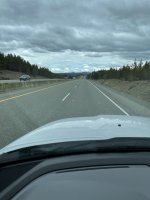
75 mph towing a pram?
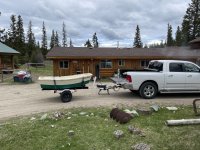
Herb and Keith stopped in Merritt to buy fresh provisions and grab lunch, I elected to just keep on keeping on and got to Mile High early. It was a nice day, dry - I didn't have to hurry to unload my truck. No rain? Amazing. Usually we're dodging rain and mosquitoes. Mosquitoes - I like them about as much as ticks. Mosquitoes were absent on this trip. Strange.
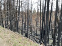
Last fall, a fire started west of Logan Lake and burned eastwards. Logan Lake was evacuated, so was Mile High Resort. The devastation in some parts of the burn are indescribable. Ponderosa Pine that appear as if they exploded halfway up the trunk, in one creek bottom, burned trees lie every which way - indiscriminately apparently, I guess the fire generated hurricane must have been swirling. Near SL-1, there were dozens of trees among the thousands charred, that had bright spots on the burnt tree trunk. It's just a guess on my part but I thought perhaps after the fire on a tree was out, the heat cooked pine sap and exploded bits of bark leaving the barkless spot. That's just a wild guess on my part.
When we couldn't seem to get trout interested in our chironomids, I realize now that I missed an opportunity to fish scuds, deep. Small scuds. I noticed large scuds, maybe 3/4" or a tad longer along the shoreline. Keith tried a big scud under his bobber and had no love. I forgot about the old Rocky Ford Creek "JLS" combo (Jeremy's Leech and Scud) where the trailing scud was an 18 and sometimes a 20. I should have tried small scuds. I will next year.
I'm really thankful that Herb, Keith and I are able to make this trip. There's a lot of planning needed so we don't forget things, like our boots, spare batteries for the sonar units, ketchup for the fish fry, tiedown ratchet straps, boat seat, passport......
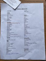
Despite having a pretty extensive checklist, I usually forget something. Part of the game.
From Osoyoos I exited 97 and took highway 3 up the Similkameen River - she's high and muddy but nothing like it was last year during BC's devasting fall floods. I saw log jams high up on the river bank from the floods of last year. The Similkameen valley has changed a lot in the 23 years I've been using this highway; vineyards are everywhere. Wineries? Dozens. Keep that in mind you wine connoissers.
The path north includes a stretch of BC 5 more commonly known as the Coquhihalla. From Merritt, the Coquihalla climbs steeply - and rapidly, the posted limit is 120 kph. Canadians are a lot like Americans, the posted limit isn't followed often.
75 mph towing a pram?
Herb and Keith stopped in Merritt to buy fresh provisions and grab lunch, I elected to just keep on keeping on and got to Mile High early. It was a nice day, dry - I didn't have to hurry to unload my truck. No rain? Amazing. Usually we're dodging rain and mosquitoes. Mosquitoes - I like them about as much as ticks. Mosquitoes were absent on this trip. Strange.
Last fall, a fire started west of Logan Lake and burned eastwards. Logan Lake was evacuated, so was Mile High Resort. The devastation in some parts of the burn are indescribable. Ponderosa Pine that appear as if they exploded halfway up the trunk, in one creek bottom, burned trees lie every which way - indiscriminately apparently, I guess the fire generated hurricane must have been swirling. Near SL-1, there were dozens of trees among the thousands charred, that had bright spots on the burnt tree trunk. It's just a guess on my part but I thought perhaps after the fire on a tree was out, the heat cooked pine sap and exploded bits of bark leaving the barkless spot. That's just a wild guess on my part.
When we couldn't seem to get trout interested in our chironomids, I realize now that I missed an opportunity to fish scuds, deep. Small scuds. I noticed large scuds, maybe 3/4" or a tad longer along the shoreline. Keith tried a big scud under his bobber and had no love. I forgot about the old Rocky Ford Creek "JLS" combo (Jeremy's Leech and Scud) where the trailing scud was an 18 and sometimes a 20. I should have tried small scuds. I will next year.
I'm really thankful that Herb, Keith and I are able to make this trip. There's a lot of planning needed so we don't forget things, like our boots, spare batteries for the sonar units, ketchup for the fish fry, tiedown ratchet straps, boat seat, passport......
Despite having a pretty extensive checklist, I usually forget something. Part of the game.