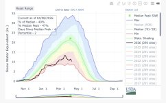
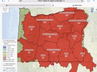
a summer of smoke, smoke and more smoke...ugh
And further bad news, Stormsurf is forecasting a El Nino cycle, which would not bode well for our future snowpack.
Rationale: A Modoki La Nina developed in the Fall/Winter of 2024-25. It faded in Summer of 2025 then started turning toward La Nina again in Aug 2025. Considering it takes 3+ months for La Nina symptoms to appear in the atmosphere after the ocean (Nino 3.4) turns solidly to a La Nina configuration, and the ocean was just starting to make clear moves towards becoming solidly La Nina in late Aug, some form of weak La Nina built into the jetstream/atmosphere in late Fall (Dec 2025). But at the surface in the West Pacific a series of 3 Westerly Wind Bursts (WWB) occurred (Dec 26, Feb and then March 2026). Note that the PDO was still be in the cool phase in Fall/Winter 2025-26 but was showing signs of turning neutral as of the time of this writing (3/29/26). The two big unknowns are what will the PDO do (will it overwhelm whatever push there is towards and ENSO) and how much if any of Hunga Tonga volcanoes effect linger in the atmosphere?
Regardless, clear signs of the development of El Nino are present in the West Pacific and are starting to affect surface water temps along Ecuador driven by 2 Kelvin Waves (discussed above). And as third WWB started building as of March 8th with east anomalies starting to develop over the Maritime Continent (all classic signal of a developing El Nino) and a change in the Walker Circulation. All the model suggest some form of El Nino developing ranging from weak to strong if not super El NIno status in late Fall 2026. The million dollar question, is not will it evolve, but rather how strong will it be? Will it stall like the 2023 El Nino, of will it be given the chance to fully express what is likely the significant latent heat signature present in the ocean. El Nino is the planets way to bleed off that excess heat, by discharging it to the atmosphere. We are currently in the Spring Unpredictability Barrier (late March 2026). And though all the models are screaming 'El Nino', there is a significant uncertainty as to the strength of whatever El NIno event is to eventually manifest. It all depends upon whether the oceanic change become coupled wit the atmosphere. And that would be expressed through clear signals of a change in the Walker Circulation.
Assuming a moderate to strong event develops, and assuming the current strong WWB underway in the West Pacific continues somewhat as forecast (3 months of continued west anomalies with 6-8 weeks of very strong anomalies through the Spring of 2026), it seems some signature of this event will make it into the atmosphere starting mid-June 2026 (3 months post the start of the 3rd WWB). That should feed energy into the southern hemi jetstream improving the odds for gale development in the South Pacific to perhaps normal status and erasing the previous bias towards La Nina (and therefore less gale development).


 www.nytimes.com