Rain

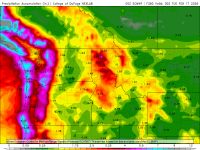
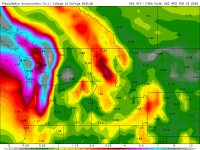
This morning's 16 day precipitation accumulation models (GFS and Euro). I also looked at the snow accumulation forecasts which suggest these storms are not exactly spawned out of the Gulf of Alaska. However, both models forecast 40"-50" of snow in the northern Oregon and Washington Cascades. I hope they verify...

feb216dayeuro.png

feb216daygfs.png
 
I wear shorts year-round, even when it snows...
Just add a hoodie and you're set. :cool:
Side note;
Was in downtown Anchorage years ago, headed for dinner at Humpies. Ambient temp was -19 according to the local bank. Had to pass by the convention center, which had an MMA event going on.

The crowd waiting to get in was blocking the street and sidewalk. As I passed through I found a guy wearing a t shirt, gym shorts, socks and flip flops. I guess he saw the look on my face, because he told me not to worry he was just fine.
 
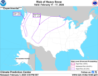
Climate Prediction Center has just issued a slight (20%-40%) risk for heavy snow. FIngers and toes crossed...

1770159109085.png

Detailed Summary

For Friday February 06 - Tuesday February 10: WPC Days 3-7 U.S. Hazards

For Wednesday February 11 - Tuesday February 17:

The other half of this pattern change is across the West where a welcome transition to a wetter pattern appears to be on tap. Early in week-2, an initial mid-level trough is forecast to move through, while the ECENS based tools are a little drier today relative to yesterday, the GEFS maintains robust chances of 3-day accumulated precipitation exceeding the 85th climatological percentile and 1 inch over parts of southern California and the Desert Southwest. Therefore, the forecast maintains a slight risk of heavy precipitation for Feb 11-12 over this region. Across the higher elevations of the interior West and into the Central and Northern Plains and Upper Mississippi Valley, there are some chances for heavy snow associated with this initial system. As such, a slight risk of heavy snow is posted for Feb 11-12 across these areas.

At the start of the period, upstream of the trough over the western CONUS, another trough is forecast in the vicinity of southwestern Alaska. This system brings elevated chances of precipitation to portions of the south-central, southeastern Mainland and Southeast Alaska. PETs from the GEFS and ECENS indicate enhanced chances of 3-day precipitation totals exceeding the 85th climatological percentile and 2 inches early in week-2. However, raw forecast guidance indicates about 2 inches of precipitation in 72 hours which is unlikely to lead to hazardous conditions. Therefore, no corresponding hazard is posted today.

The trough is then forecast to progress southeast and near the West Coast. PETs from the GEFS and ECENS indicate enhanced chances of 3 day precipitation amounts exceeding the 85th climatological percentile and 2 inches across the Pacific Northwest. Uncalibrated forecast guidance also indicates elevated chances of precipitation exceeding 2 inches of liquid equivalent precipitation over the Cascades and Sierra Nevada. Therefore, a slight risk of heavy snow is posted for Feb 13-17 due to one or more periods of enhanced precipitation during the middle to end of week-2.

The deterministic ECMWF, CMC, and GFS models all show the potential for periodic strong winds across the Front Range and High Plains. The models are not in agreement on the specifics of location and timing, but all show periods of enhanced high wind risk from either a tight pressure gradient and upsloping winds from the east, or downsloping chinook winds from the west. Affected locations, if any, will vary with time, but with the models inconsistent in forecasting exactly which locations will be affected on which days, the whole area is broad-brushed with a slight risk of high winds that continues through week-2.

Forecaster: Ryan Bolt
 
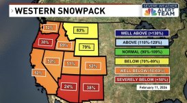
"Cold and wet means snow...and lots of it...for the entire West Coast. Here are the totals through February 25th. Let's say that skiers will have big smiles on their faces. So will those concerned about snowpack."

 
"Cold and wet means snow...and lots of it...for the entire West Coast. Here are the totals through February 25th. Let's say that skiers will have big smiles on their faces. So will those concerned about snowpack."

Let's hope Cliff is right. I jokingly suggested to some folks that I was going to put my snow shovels away for the winter in hopes that it would start snowing.
 
The non winter, with more 50's than 30's...
Meh...
 
Let's hope Cliff is right. I jokingly suggested to some folks that I was going to put my snow shovels away for the winter in hopes that it would start snowing.
☃️

I won't get my hopes up til it's landed on my lawn.
If your lawn is near sea level maybe not but east of you where it's really needed, probably...


There is a reader comment in the Cliff Mass article that about how mountain snow in April has caused maintenance delays over his long career until as late as June. My wife and I have done many regional Valentines getaways over the last 45 years. There have been several where we encountered heavy snowstorms, even along the coast as recently as 2025 where I had to follow a snowplow!

It could happen...
 
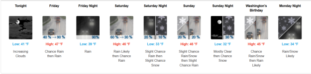
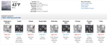
Snow was supposed to happen last Saturday. Didn't...

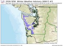
Now:

1771277411440.png

Gotta believe meteorologists at their word.... Riiight....
 
Lol.....they are now into the hyperbole propaganda dept.
 
It rained in '88 at the viewpoint, by the bathroom. Big line outside the bathroom!!! In '88 when it rained. Still an issue these days when it rains and you are standing in line for the bathroom.
 
Back
Top