
SFR onX mapping

Sorta fishing-related

FinLuver

Native Oregonian…1846
I rent a home and a recent property line dispute brought to attention that onX mapping may not be as accurate as some would expect. It’s a residential neighborhood built in the early to mid-1990s. The property lines are about 5-10’ ft off. I suspect a public walk easement, maybe an afterthought and was put in place at a later time, may have shifted the original plots. But, they also may have never properly documented the changes with the assessor’s office, causing the errant mapping.

What makes me think this, you might be asking?

The line shows two anomalies…

1) the lines drawn are right on the edge of the homes.

2) the line drawn goes right thru the neighbor’s shed in the backyard.
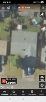
image_1.jpeg
 
Last edited:
I agree with Charles, trust neither the lines or the photogrametry. Technician at the assessors office do the best they can to input plats and deeds, but they are not surveyors, and they can't make judicial decisions. Photos may not be georeferenced as well as we'd like. All the photo's will contain scale errors. A counties base GIS is a reference tool only.
 
Last edited:
I had a survey done fifteen years ago, and the surveyor found a mistake made (40 years ago)half a mile up the road that shifted everyone's lines fifty feet. I paid 300 bucks to the county to split the difference with my neighbor and record it as such. Rest of the folks on the road will find out eventually.
 
I agree with Charles, trust neither the lines or the photogrametry. Technician at the assessors office do the best they can to input plats and deeds, but they are not surveyors, and they can't make judicial decisions. Photos may not be georeferenced as well as we'd like. All the photo's will contain scale errors. A counties base GIS is a reference tool only.
Round earth, flat peice of paper is how I explain it to people. I am not sure if that is the actual reason for any of the errors but people seem to accept it.
I have noticed that the program that I use got a lot better a couple of years ago. I have heard that the data tends to get better over time. I doubt that GIS will ever be as accurate as a survey.
OnX or Gaia or whatever other system you want to use is pretty accurate for the majority of things that they are used for.
 
Your phone is also not terribly accurate. I just wrapped up a couple of weeks mapping vernal pools during amphibian surveys, using an iPad running ArcGIS. The built-in gps receiver was only good for about 3-4m accuracy so I picked up a cheap (~$110) Garmin GLO 2 receiver to add additional satellites, and that bumped it to ~1.5-2m accuracy (which was probably sufficient for project needs) without having to pay for post-hoc differential correction. It's a pretty neat little antenna, although battery life was way shorter than advertised - bring a power bank!
 
Things like Google Maps, OnX, etc that use satellite imaging often suffer from parallax and projection errors and tend to be off by roughly 5-10 feet. Close enough for the use most people put it to, but definitely not something I'd use to replace corner stakes and actual surveying. It is, in fact, the driving force behind continued ground-trothing.
 
I could see onx being a little off. I could also see a neighbor building a shed on a property line😬🤣
OnX is using county data as the original source. That is who is "a little off". And that is more of a concern than OnX.

Property lines outside of urban areas are ALWAYS an adventure. A SHED??......when I worked for BLM in North Idaho, we had COMPLETE THREE BEDROOM TWO BATH homes in trespass on public lands. It took an Act of Congress to resolve the mess.

My neighbor is currently trespassing on DNR land. I am waiting to see how long it takes for DNR to notice. It might be years. I only noticed because I surveyed my property lines from the last KNOWN correct property post.
 
Last edited:
County and city data is often off. They know it, explain such.
Also as noted, mistakes are often made decades ago that were never caught.
One city i worked at received aerial mapping for free as a by product from the power company, then “tried” overlaying it to arc gis maps.
Hence it’s only a reference, hire a surveyor.
 
I create the kind of data that onX uses. It's created solely for the county assessor to use (all assessor websites will have a disclaimer you have to click past), it's just available to everyone because it's public information, for better or for worse. It's not close to survey grade for a bunch of reasons. onX and a bunch of companies like google scrape it from county assessor sites and aggregate it in their apps for you to use at your own risk. It's "good enough" most of the time. This could be a mapping issue, or an actual encroachment. I see both all the time.

Don't use it for any kind of property dispute, hire a surveyor. If you live in a platted neighborhood, you should be able to get a copy of your neighborhood plat, that would most likely show if there is a walkway easement.
 
Round earth, flat peice of paper is how I explain it to people. I am not sure if that is the actual reason for any of the errors but people seem to accept it.
I have noticed that the program that I use got a lot better a couple of years ago. I have heard that the data tends to get better over time. I doubt that GIS will ever be as accurate as a survey.
OnX or Gaia or whatever other system you want to use is pretty accurate for the majority of things that they are used for.
Do you use ArcGIS? I used to play with it since my uncle in MT worked with it, he even wrote a book on it.

I'm sure there are other programs out there, but it was pretty cool. I have a few people I know at Tetratech that have used it too.

Just curious.
 
Do you use ArcGIS? I used to play with it since my uncle in MT worked with it, he even wrote a book on it.

I'm sure there are other programs out there, but it was pretty cool. I have a few people I know at Tetratech that have used it too.

Just curious.
I've been teaching ESRI ArcGIS at the CC for over a decade. Started with Map, now running Pro. First started seeing it at the land survey conventions in the early 90's and been helping build them since about 2005. Really an incredible tool. The mapping is just part of a whole information storage and data analysis system. It's fun. Hard for me to call it work, I enjoyed it.
 
Last edited:
I've been teaching ESRI ArcGIS at the CC for over a decade. Started with Map, now running Pro. First started seeing it at the land survey conventions in the early 90's and been helping build them since about 2005. Really an incredible tool. The mapping is just part of a whole information storage and data analysis system. It's fun. Hard for me to call it work, I enjoyed it.
Yeah, I know it does a lot and moving data around is cool too! The mapping has always interested me and I still like and have quite a few paper maps! No battery required!!

I haven't tried in a long time, but it's always interested me!

My uncles book! I might still have a copy!
 
OnX is definitely not accurate. I stood over one of survey pegs and marked the location with a gps. When I looked at it on the map, one of the marks was off by 15 yards. I have also marked waypoints for gates and road intersection, only to discover the waypoints are off from the locations.
 
OnX is definitely not accurate. I stood over one of survey pegs and marked the location with a gps. When I looked at it on the map, one of the marks was off by 15 yards. I have also marked waypoints for gates and road intersection, only to discover the waypoints are off from the locations.
Not unexpected. The GPS is often solving long, skinny triangles with one variable being time, used to compute distance, measured at the speed of light, by comparing sending and receiving clocks. Atmospheric conditions, signal interference and/or overhead cover affects the nominal signal time, and therefore positional reliability.
 
Last edited:
Many-many moons ago, we moved into our home in a new development of one acre partially wooded lots. A little over a year later I noticed survey stakes on one side of the property where 2nd owners had just moved in. It looked rather odd because a bunch of the neighbor's landscaping; ornamental trees, some pavers... were on our side of the stakes, and their house was maybe 15 feet from the stakes on a one acre lot!

In the meantime, there was no fence along the sides of our property and the neighbor on the other side was putting up a fence to keep his dog in. Our Lab was regularly visiting the neighbors' homes nearby and knew we needed to put up a fence to keep her in our yard even though they assured us that she was a good dog that their kids enjoyed playing with, and asked if they could have "visitor privileges".

I found the county plat map and the survey monument in the road and got out a tape measure and my lensatic compass. Sure 'nuff, our two houses had been sited pretty far off center on our lots, possibly because of erratics from the ancient glacial morraine we live over; there are several large bathtub sized rocks on the surface of our property. At any rate I went and spoke to the new neighbor to let him know our plans. He wasn't thrilled but acknowledged our shared property line. I felt pretty bad when I had to tell him one of our fence post holes actually hit the end of one of his drainfield pipes.
 
Back
Top