

I heavily use online and offline Google and Gaia satellite and topo maps for finding - exploring, and planning for places to fish, plus rely on them for road and trail navigation.
I use additional data sources for planning, and in the field for weather, river levels, regs, plus a fishing journal.
Today I got a Fly Fishers International (FFI) club email mentioning a new fishing app called onWater app with online-offline maps.
 www.onwaterapp.com
It's pretty expensive at a $50 annual subscription for a nationwide 2D 3D map app with a private property boundaries layer but if its not a good field navigation tool I probably would not get a subscription in addition to Gaia and my other data sources. However it has layers and features that Gaia and onX don't have like:
www.onwaterapp.com
It's pretty expensive at a $50 annual subscription for a nationwide 2D 3D map app with a private property boundaries layer but if its not a good field navigation tool I probably would not get a subscription in addition to Gaia and my other data sources. However it has layers and features that Gaia and onX don't have like:
LIVE FORECASTING & CONDITIONS - weather conditions, flow rates, water levels, temperature, clarity
FISHING REPORTS I rarely check fishing report sites.
POINTS OF INTEREST - points of interest that contains tackle shops, in addition to campgrounds, boat ramps, etc. that many maps have.
PHOTO JOURNAL - "private" fishing journal.
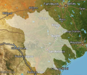
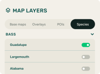
FISH SPECIES MAP - apparently identifies the local geographic ranges of specific fish species . I would find that particularly interesting.
Is anyone using it? Your thoughts? Does it work well as a trail navigation app?
BTW, does anyone know of data sources that identify NW regional geographic habitat - ranges for specific fish species (not what rock to stand on!)?
I use additional data sources for planning, and in the field for weather, river levels, regs, plus a fishing journal.
Today I got a Fly Fishers International (FFI) club email mentioning a new fishing app called onWater app with online-offline maps.
onWater Fish - Fishing Maps, Conditions, and Access
Everything you need to plan a trip and enhance your day on the river. All in one place.
www.onwaterapp.com
LIVE FORECASTING & CONDITIONS - weather conditions, flow rates, water levels, temperature, clarity
FISHING REPORTS I rarely check fishing report sites.
POINTS OF INTEREST - points of interest that contains tackle shops, in addition to campgrounds, boat ramps, etc. that many maps have.
PHOTO JOURNAL - "private" fishing journal.
FISH SPECIES MAP - apparently identifies the local geographic ranges of specific fish species
. I would find that particularly interesting.Is anyone using it? Your thoughts? Does it work well as a trail navigation app?
BTW, does anyone know of data sources that identify NW regional geographic habitat - ranges for specific fish species (not what rock to stand on!)?
ex. there is a scientific paper showing data of ranges for CT, RT, and I believe EBT in an S river.