Lidar is cool. Our <1m coverage in SE AK is miniscule, but that should change in the coming years.
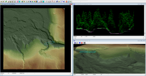
One of my local juvenile fish survey areas has great lidar coverage, and I used some of those files and nifty online viewer (FugroView) to answer some broad questions about streambed gradient and the possible presence of barriers to anadromy. Below is a screenshot of the viewer - the left hand frame has an overview of the stream rendered in TIN (triangulated irregular network, easy way to represent bare earth features) with a blue bounding rectangle over both the main channel and the tributary channel I was curious about. The bottom right view is the 3D representation of the left frame as viewed from downstream, with the bounding retangle hovering above the surface. The upper right hand box is the point cloud within the bounding rectangle as viewed from ground level - the main channel is the wide flat to the far right, the trib channel is the small U to the left. With this I can move the bounding rectangle up and down the tributary channel looking for potential barriers that may exclude anadromous fish from using the upstream habitat and compare/measure surface height relative to the known surface height of the creek...
Did I mention lidar is cool?
View attachment 23847





 . He's a serious rockhound that has audited the 300 series courses at CWU and has a full lapidary shop. This morning I went to the