Grimes Lake

Years ago I got lost out in there and ended up on that H road. It was doable until the spot it drops down the hill side, at which point I was lost and not feeling like getting my rig stuck in the middle of nowhere was a good idea, so I turned around. If that drop down the hill got fixed up it would be very doable to take that road into the south end. Looked like only a few spots that had really bad ruts that made me nervous.

I guess the point I'm trying to make, it's probably not that far fetched to access the lake from the H Road side.

Heck, if they couldn't figure out how to fix the road, a small gravel lot up on top of the hill would leave less than a mile hike to get down to the lake. Another Dusty.
 
It has been years since I looked at the Douglas County road atlas. I was looking for a access road so I could spend the night at Grimes Lake instead of leaving.

As I remember the road ended up somewhere on the north end. It was owned by the county, but not used. I did talk to somebody in the county and they basically said you don't want to drive it.

BUT it is legal access and it is easier to reconstruct a existing road, than to get the ok to build a new road from BLM.

Did you look at the road atlas for Douglas County? That will give you more info than the parcel map.

It will probably be difficult to get Douglas County to improve that road, but BLM might do it under a cooperative agreement particularly if it provides access to Grimes Lake.

These days, the fishing community might need to raise funds for access and a boat launch and camping area.

Somebody probably should contact the game department and ask their thoughts on the future of Grimes Lake from their perspective. And BLM as well. Jameson Lake resort probably gets some decent revenue from Grimes Lake fisherman. They would "balance" the discussion when it came to County Commissioners and Douglas County property owners.

The simplest solution is for the state of Washington to simply buy the land and the road access. Otherwise it might lead to another Chopaka Lake outcome.

I wonder if the LLC would be interested in selling.

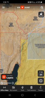
Unfortunately from the north you would have to navigate a nasty drainage to access from the road. The private butt's up to the rock slide. See onx:
Screenshot_20250424_155652_onX Hunt.jpg

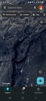
Google map showing the more rough terrain:
Screenshot_20250424_163709_Maps.jpg
 
Unfortunately from the north you would have to navigate a nasty drainage to access from the road. The private butt's up to the rock slide. See onx:
I went on Google Earth and took a look after your note.

When I looked at the county road atlas I was thinking that there were some farmsteads in that area and that there were county roads to them. Even if the farmsteads were abandoned, the legal road access is still there.

I believe I looked at Road H or Road I heading north. When I realized that there was a nasty drainage between the road and the lake I gave up following up. Having the county engineer tell me he would not drive it I dropped looking for access to the lake. Though I suspect the old-timers that lived in the area probably had a route down to the lake.

However, the county road atlas did not show the BLM roads. After looking at the Google Earth image I concur with Long_Rod_Silver that it appears that the access is easily doable from Road H to Grimes Lake.

Anytime, you have a straight road alignment like that it usually means the road is drivable. Ruts are really not an issue, a bit of gravel can fix that rather cheaply. In that country, I suspect the dirt isn't very deep until it hits bedrock.

I would be interested in hearing from Long_Rod_Silver on the issues with the area that he decided to turn around. On the Google Earth image it looks fairly easy. Looking at that road alignment I would have probably taken my trailer down that road (it is a small trailer).

BLM and all Federal agencies have been closing lightly used roads for environmental reasons. It might not be open.

Sounds like the road could use some gravel and looking at the satellite image it would probably be worthwhile to put in some inter-visible turnouts if that ends up being the main access point.

It is definitely an option should the current access be closed down.
 
I think we are overthinking this. It's going to be almost impossible to create a new road over endangered Pygmy rabbit and Sage Grouse habitat. I think the best bet we can hope for is hike in access along the current road in. I don't see how the ranch can block what appears to be a county road but they probably will attempt to.

The state should open the lake up to year round access. This could put pressure on the ranch to make a deal because of the hunting club/lease aspect.
 
I went on Google Earth and took a look after your note.

When I looked at the county road atlas I was thinking that there were some farmsteads in that area and that there were county roads to them. Even if the farmsteads were abandoned, the legal road access is still there.

I believe I looked at Road H or Road I heading north. When I realized that there was a nasty drainage between the road and the lake I gave up following up. Having the county engineer tell me he would not drive it I dropped looking for access to the lake. Though I suspect the old-timers that lived in the area probably had a route down to the lake.

However, the county road atlas did not show the BLM roads. After looking at the Google Earth image I concur with Long_Rod_Silver that it appears that the access is easily doable from Road H to Grimes Lake.

Anytime, you have a straight road alignment like that it usually means the road is drivable. Ruts are really not an issue, a bit of gravel can fix that rather cheaply. In that country, I suspect the dirt isn't very deep until it hits bedrock.

I would be interested in hearing from Long_Rod_Silver on the issues with the area that he decided to turn around. On the Google Earth image it looks fairly easy. Looking at that road alignment I would have probably taken my trailer down that road (it is a small trailer).

BLM and all Federal agencies have been closing lightly used roads for environmental reasons. It might not be open.

Sounds like the road could use some gravel and looking at the satellite image it would probably be worthwhile to put in some inter-visible turnouts if that ends up being the main access point.

It is definitely an option should the current access be closed down.
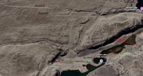
I checked it out in Google Earth as well, to see what that existing back road looks like. I was able to spin and angle the view to get a feel for the terrain and elevation change. It looks pretty do-able, but stuff always looks easier in the view from way above than in real life on the ground! Still, a dozer cut or grader cut plus gravel could re-fresh that road into a usable access.

Here's a marked up screen shot from Google Earth.
Grimes Back Road Google Earth.jpg
 
I checked it out in Google Earth as well, to see what that existing back road looks like. I was able to spin and angle the view to get a feel for the terrain and elevation change. It looks pretty do-able, but stuff always looks easier in the view from way above than in real life on the ground! Still, a dozer cut or grader cut plus gravel could re-fresh that road into a usable access.

Here's a marked up screen shot from Google Earth.
View attachment 150906
I love your signature quote!
 
Thanks for posting the 3-D image. It provides a lot more information than the overhead view.

Looks like three spots that might be interesting, but as you mention they are fairly short.

Total length of the road is 2.5 miles.

Are you going to check it out in person??
 
Last edited:
Thanks for posting the 3-D image. It provides a lot more information than the overhead view.

Looks like three spots that might be interesting, but as you mention they are fairly short.

Total length of the road is 2.5 miles.

Are you going to check it out in person??
Oh if I lived closer I would for sure. But I'm over here on the wetside. I've been to Grimes exactly one time and that was just to check it out, we didn't even fish that day. But it's always been on my mental short list of places to go, so this thread piqued my interest. Plus I just love looking at maps.
 
I’m with @Billy, gate it and make it a walk in.
👎👎👎 I'm not with you and I'm not with Billy on the walk in. I want to be able to fish from a boat (my pram).

It's not a long hike to the so called boat launch from North Jameson Lake Road but who kicks in a float tube down that long skinny channel? Only someone not familiar with the lake, so you keep walking to the main body of the lake through the shrub steppe vegetation.

Is the county going to allow people to park in the right of way (North Jameson Lake Rd)? I don't seem to recall much of a shoulder.

Sorry for the rant, feelin' a bit sad that this lake and its amazing fishery is likely going to be lost. I have so many fond memories of outings to Grimes.
 
👎👎👎 I'm not with you and I'm not with Billy on the walk in. I want to be able to fish from a boat (my pram).

It's not a long hike to the so called boat launch from North Jameson Lake Road but who kicks in a float tube down that long skinny channel? Only someone not familiar with the lake, so you keep walking to the main body of the lake through the shrub steppe vegetation.

Is the county going to allow people to park in the right of way (North Jameson Lake Rd)? I don't seem to recall much of a shoulder.

Sorry for the rant, feelin' a bit sad that this lake and its amazing fishery is likely going to be lost. I have so many fond memories of outings to Grimes.
I'm mad about it too, Pat, and I've never even fished there! I guess it's because I always planned to someday.

But if they did gate it and not renew the lease, can we assume that Witt Farms would still allow trespassing on foot to walk in? We'd still be covering the same private property, just on foot not in a vehicle.
 
I imagine that the state put the road and dike into the parking area. If the lease isn’t renewed, the state should charge Witt Farms for it. Like Merle, I put off fishing there too long….
 
Lots of comments and thoughts but I have to wonder what the reasoning is for not renewing the lease?
Could it be that they are tired of "unsportsmen like sportsmen", fire danger caused by idiots, a pay to play plan, or just don't need the money. Without stocking they could restrict rod numbers and have some banner years until the fish aged out but I don't see an avenue for continued private Lahontan stocking if private lake/guiding is the plan.
Does anyone know a resource to see what they were getting annually for the lease?
 
Could any of not getting a lease renewed related to the state's deficit?

How does one expect the state to improve access with the state's current budget issues/crisis?
 
Last edited:
👎👎👎 I'm not with you and I'm not with Billy on the walk in. I want to be able to fish from a boat (my pram).

It's not a long hike to the so called boat launch from North Jameson Lake Road but who kicks in a float tube down that long skinny channel? Only someone not familiar with the lake, so you keep walking to the main body of the lake through the shrub steppe vegetation.

Is the county going to allow people to park in the right of way (North Jameson Lake Rd)? I don't seem to recall much of a shoulder.

Sorry for the rant, feelin' a bit sad that this lake and its amazing fishery is likely going to be lost. I have so many fond memories of outings to Grimes.

I’m fighting the urge to pick a fight.

I know you’ve witnessed first hand that most of our stillwater options out here in EWA are absolutely thrashed by the public. I’m for gating/trailheading it all and making it walk in.
 
It's pretty easy for me to expect the state to do better.
I’m fighting the urge to pick a fight.

I know you’ve witnessed first hand that most of our stillwater options out here in EWA are absolutely thrashed by the public. I’m for gating/trailheading it all and making it walk in.
I suspect if you and I face off in the ring you'd have a knockout in a few seconds! ;-)

I'm going to argue: not all of our stillwater options here in the Basin (I don't know about east of us) are thrashed by the public. I've fished three lakes this spring that, while not PRISTINE, didn't have much human waste everywhere. And like @Stonedfish, I haul other peoples beer cans and bottles back to my truck on my hikes back.

I do hike my float tube into lakes, many times a year but Grimes isn't one I want to float tube in (Been there, done that); it's large enough and often with sudden STRONG winds that I want the option of hauling ass in my pram to the launch. I'm also no spring chicken anymore. Besides, with a float tube when nature calls, it's a shore trip.

Back to the start of this thread: The loss of lease issue has nothing to do with the budget, nor with un-sportsman like sportsmen, or fire danger or any other failure of WDFW/the state. Wittig Farms, LLC will not renew the lease with the state at Grimes due to a dispute between the the LLC and the state on a separate issue.

Sayonara Grimes. Going to miss you.


ps. Personally: I'd pay a management company a daily use fee if I could just drive my damn truck to that so-called launch.
 
Back
Top