Chinook observed in Klamath River tributary above Iron Gate

I copy and pasted the latest video weir summary for the Upper Klamath. Jenny and Shovel Creeks are both newly accessible tributaries. There is also significant mainstem spawning underway above the Copco Reservoir footprint which will be tallied when fall spawner surveys are completed. Coho are just beginning to show in the upper basin. The Scott has always had the largest run while the Shasta generally has just a few hundred fish in a good year.

The California Department of Fish and Wildlife annually operates adult fish counting facilities on the Shasta River, Scott River, Bogus Creek, Jenny Creek and Shovel Creek. This in-season update provides preliminary 2024 returns of Fall-run Chinook Salmon and Coho Salmon to each counting facility. Preliminary in-season updates will be provided as data becomes available throughout the season. The Shasta River station was operational on August 29, 2024 and 4,869 adult Chinook Salmon and 9 adult Coho Salmon have been observed through November 13, 2024. The Bogus Creek station was operational on September 5, 2024 and 340 adult Chinook Salmon and 0 adult Coho Salmon have been observed through November 12, 2024. The Scott River station was operational on September 13, 2024 and 557 adult Chinook Salmon and 142 adult Coho Salmon have been observed through November 13, 2024. Jenny Creek weir began operating on September 26, 2024 and 310 Chinook Salmon, 0 Coho Salmon have been observed as of November 11, 2024. Shovel Creek weir began operating on October 16, 2024 and 198 Chinook Salmon and 0 Coho Salmon have been observed as of November 8, 2024.

The Shasta River station is located roughly 600 feet from the confluence with the Klamath River and serves as a census for the entire Shasta River. The Scott River station is 18 miles upstream of the confluence with the Klamath River and the Bogus Creek station is 0.25 miles upstream of the confluence with the Klamath River. Depending on the year significant fractions of the adult salmonid populations in the Scott River and Bogus Creek spawn downstream of the counting stations. This in-season update doesn’t report the spawning escapement that is observed downstream of these stations. Final reports detailing the total escapement to each river will be available after the data is finalized.
What is the origin of these salmon?
 
What is the origin of these salmon?
We won't know for sure until CA DFW summarizes carcass surveys but I suspect it's a combination of wild and Iron Gate hatchery fish. There's significant wild chinook in river spawning that used to occur from below Iron Gate Hatchery all the way to Happy Camp. That area has been impacted by silt from dam removal so at least some of those fish likely continued up river until they found suitable spawning habitat.
 
Fishing in the Klamath River is moving to the top of my bucket list.
I've been studying google map to find a good route to get there from here.
Growing up in Medford when I was a kid the stories of trout fishing was high lighted by the guy telling the story by saying: I saw more rattle snakes than trout".
 
Much of the lower and mid Klamath watershed is getting hammered with low elevation snow and rain over the past 24 hours. As temperatures rise, we'll be getting some rain on snow action. The Klamath is forecast to peak at 106,000 CFS Friday evening in Klamath Glen near the mouth. That should really help move the many tons of material released when the dams were removed.

Meanwhile, the upper Klamath, is also getting precip but not at the same extreme rate thanks in part to rain shadowing by Mt. Shasta and the Cascades. Hopefully water levels will remain below the "redd scouring threshold" in all of the newly colonized habitat. So far the Klamath at Iron Gate has only gone up about 70 CFS since the start of this event though I expect flows will increase substantially over the 24-48 hours.
 
Fishing in the Klamath River is moving to the top of my bucket list.
I've been studying google map to find a good route to get there from here.
Growing up in Medford when I was a kid the stories of trout fishing was high lighted by the guy telling the story by saying: I saw more rattle snakes than trout".
One fine spring day in 1976 or '77 my buddy and I headed to the tailwater John C Boyle dam's powerhouse. Big salmon flies were hatching and we were trying to fool a few fish with our very crude flies (and me with a spinning rod/casting bubble). The first rock slide I crossed a rattler buzzed at me. I couldn't see the snake so I detoured up and around where I think the snake was hiding. Stepped onto the gravel bar close to some brush and another rattler buzzed at me. Sort of ruined my focus on the water. ;-)

I'm excited to follow the on going story of salmon returning the the Klamath!
 
Maybe if they keep doing emergency closures of commercial fisheries in the gulf of Alaska we'll keep getting "record returns" so the Klamath River fish will have a good chance.
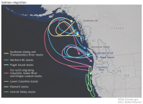
Salmon in California and Southern Oregon, including these Klamath River fish, generally do not need to migrate to the Gulf of Alaska (see here). These Klamath and Central California fish just head offshore to grow from Southern Oregon through Central California.
Screenshot 2024-11-21 at 6.38.13 PM.png
These California and Southern Oregon chinook and coho take advantage of the year-round upwelling and resources to grow off the coast of these states. Northern Oregon, Washington, and B.C. fish migrate to the Gulf of Alaska because these areas experience "downwelling" in the winter. Because of downwelling, there is very little phytoplankton = very little food in these areas in the winter. The out migrating salmon swim north to find food. The oceanographic currents set up an upwelling gyre in the Gulf of Alaska.
This difference in salmons' marine behavior is driven ultimately by food supply and that is driven by upwelling vs. downwelling oceanographic conditions. During coastal upwelling, winds from the north combine with the Coriolis effect to drive surface waters offshore and are replaced by colder, nutrient-rich water. Phytoplankton need light + nutrients to grow; they feed krill and copepods which feed bait fish which feed salmon. During coastal downwelling, winds from the south combine with the Coriolis effect to drive warmer, nutrient-poor surface waters against the coast. No nutrients means no phytoplankton and no food web.
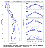
This figure shows seasonal changes in several upwelling indices along the Pacific coast (from here). These indices use seasonal wind directions and intensities to predict the intensity of upwelling. Values greater than 0 indicate that the winds favor coastal upwelling. Negative values favor coastal downwelling. For reference: 45oN = Lincoln City, OR; 42oN = just south of Brookings, OR; 39oN = just north of Point Arena, CA; 36oN = south of Big Sur, CA; 33oN = Solana Beach, CA.
Screenshot 2024-11-21 at 6.48.38 PM.png
At all the California locations, values throughout the year are zero or better, producing year-round upwelling. But at 42oN and 45oN upwelling values are negative in the winter (even worse off WA and B.C.); that means downwelling and that means no phytoplankton. In summer, the winds shift and we experience upwelling off the Washington coast (but not as extreme as California). This seasonal oceanographic regime drives killer whale migrations too. The Southern Resident Killer whales that are scarfing tons of chum salmon in the South Puget Sound right now often migrate as far as Monterey Bay in the winter to feed on Central California chinook; they can't just migrate offshore of Washington because there aren't any overwintering salmon for them to eat.
The "North of Falcon" salmon-harvest negotiations have that name because the salmon from rivers north of Cape Falcon (north of Manzanita / Nehalem) generally migrate to Alaska while stocks from rivers south of Cape Falcon remain off the California or Oregon coasts (roughly...). The fish that migrate to Alaska become a bouillabaisse of stocks that belong to Oregon, Washington, B.C., and Alaska. The negotiations are supposed to determine who gets what...
Steve

 
Last edited:
Salmon in California and Southern Oregon, including these Klamath River fish, generally do not need to migrate to the Gulf of Alaska (see here). These Klamath and Central California fish just head offshore to grow from Southern Oregon through Central California.
View attachment 133493
These California and Southern Oregon chinook and coho take advantage of the year-round upwelling and resources to grow off the coast of these states. Northern Oregon, Washington, and B.C. fish migrate to the Gulf of Alaska because these areas experience "downwelling" in the winter. Because of downwelling, there is very little phytoplankton = very little food in these areas in the winter. The out migrating salmon swim north to find food. The oceanographic currents set up an upwelling gyre in the Gulf of Alaska.
This difference in salmons' marine behavior is driven ultimately by food supply and that is driven by upwelling vs. downwelling oceanographic conditions. During coastal upwelling, winds from the north combine with the Coriolis effect to drive surface waters offshore and are replaced by colder, nutrient-rich water. Phytoplankton need light + nutrients to grow; they feed krill and copepods which feed bait fish which feed salmon. During coastal downwelling, winds from the south combine with the Coriolis effect to drive warmer, nutrient-poor surface waters against the coast. No nutrients means no phytoplankton and no food web.
This figure shows seasonal changes in several upwelling indices along the Pacific coast (from here). These indices use seasonal wind directions and intensities to predict the intensity of upwelling. Values greater than 0 indicate that the winds favor coastal upwelling. Negative values favor coastal downwelling. For reference: 45oN = Lincoln City, OR; 42oN = just south of Brookings, OR; 39oN = just north of Point Arena, CA; 36oN = south of Big Sur, CA; 33oN = Solana Beach, CA.
View attachment 133494
At all the California locations, values throughout the year are zero or better, producing year-round upwelling. But at 42oN and 45oN upwelling values are negative in the winter (even worse off WA and B.C.); that means downwelling and that means no phytoplankton. In summer, the winds shift and we experience upwelling off the Washington coast (but not as extreme as California). This seasonal oceanographic regime drives killer whale migrations too. The Southern Resident Killer whales that are scarfing tons of chum salmon in the South Puget Sound right now often migrate as far as Monterey Bay in the winter to feed on Central California chinook; they can't just migrate offshore of Washington because there aren't any overwintering salmon for them to eat.
The "North of Falcon" salmon-harvest negotiations have that name because the salmon from rivers north of Cape Falcon (north of Manzanita / Nehalem) generally migrate to Alaska while stocks from rivers south of Cape Falcon remain off the California or Oregon coasts (roughly...). The fish that migrate to Alaska become a bouillabaisse of stocks that belong to Oregon, Washington, B.C., and Alaska. The negotiations are supposed to determine who gets what...
Steve
Great information - thanks for posting!!

Cheers
 
The north migrating chinook salmon stocks along the Oregon Coast actually extend quite a bit further south than Cape Falcon. Salmon River Hatchery (located near Lincoln City) fall chinook stocks are used as a surrogate to monitor impacts by BC and Gulf of Alaska fisheries.
I copied/pasted this from a PFMC salmon document (NOC is North Oregon Coast and MOC is Mid Oregon Coast):

Far-North and North Migrating Chinook (NOC and MOC groups)
Far-north and north migrating Chinook stocks include spring and fall stocks north of and including the Elk
River, with the exception of Umpqua River spring Chinook. Based on CWT analysis, the populations from
ten major NOC river systems from the Nehalem through the Siuslaw Rivers are harvested primarily in
ocean fisheries off British Columbia and Southeast Alaska, and to a much lesser degree in Council area and
terminal area (state waters) fisheries off Washington and Oregon. CWT analysis indicates populations from
five major MOC systems, from the Coos through the Elk Rivers, are harvested primarily in ocean fisheries
off British Columbia, Washington, Oregon, and in terminal area fisheries. Minor catches occur in
California fisheries, and variable catches have been observed in southeast Alaska troll fisheries.


Klamath River Fall Chinook in river and ocean fisheries are tightly managed by the state and feds. The KMZ (Klamath Management Zone) stretches from Humbug Mountain just south of Port Orford down to Horse Mountain south of Eureka. This is the area where ocean fisheries have the highest impacts on Klamath stocks. There are also significant ocean harvest impacts that occur off both Central Oregon (south of Falcon) and North/Central California. These zones can also be impacted if Klamath stocks are depressed. The ocean harvest closure south of Cape Falcon two years ago was due to depressed Klamath and (to a lesser degree) CA Central Valley stocks.

There's a currently a working group consisting of all of the stakeholders that will be carefully watching the impacts of dam removal on Klamath stocks. They will be making recommendations to the PFMC during the harvest season crafting process which begins in February.
 
Last edited:
Here's the narrative from the latest video weir summaries for the upper Klamath - the numbers are preliminary and do not include sonar data. Shovel Creek and Jenny Creek are both located above at or above the footprint of Iron Gate Dam. ODFW is responsible for spawner counts in Spencer Creek - the latest estimate there is 130 adults. There's also some spawning in Fall Creek below where the fish rearing facility has been relocated.

I wanted to add that anecdotally (Bob creel survey ;)), there has been exceptionally good steelhead returns to the upper tributaries this fall. CADFW counts steelhead and lamprey passing through the weirs though they don't publish the results. With all of the rain in the forecast, the weirs will likely be pulled for the season within the next few days.

Klamath River Project Adult Fish Counting Facility In-season Update December 19, 2024. The California Department of Fish and Wildlife annually operates adult fish counting facilities on the Shasta River, Scott River, Bogus Creek, Jenny Creek and Shovel Creek. This in-season update provides preliminary 2024 returns of Fall-run Chinook Salmon and Coho Salmon to each counting facility. Preliminary in-season updates will be provided as data becomes available throughout the season. The Shasta River station was operational on August 29, 2024 and 4,943 adult Chinook Salmon and 32 adult Coho Salmon have been observed through December 17,2024. The Bogus Creek station was operational on September 5, 2024 and 352 adult Chinook Salmon and 19 adult Coho Salmon have been observed through December 17, 2024. The Scott River station was operational on September 13, 2024 and 599 adult Chinook Salmon and 705 adult Coho Salmon have been observed through December 12, 2024. Jenny Creek weir began operating on September 26, 2024 and 334 Chinook Salmon and 3 Coho Salmon have been observed as of December 17, 2024. Shovel Creek weir began operating on October 16, 2024 and 254 Chinook Salmon and 4 Coho Salmon have been observed as of December 12, 2024.
 
'Nookies digging redds in the Williamson....wow!


“For the first time in more than a century the salmon have returned home to the aboriginal territory of the Klamath, Modoc, and Yahooskin Paiute people,” the release noted.

“Creator’s gifts, given to us since time immemorial our relatives, the ci’yaals are making their way home through a gauntlet of obstacles, impediments and toxic water,” Chairman William Ray, Jr. said in the statement. “The Creator blesses us on this day that our c’yaals are coming home, which have been gone from our culture and way of life since 1909.”
 
I copied and pasted the latest weekly Klamath River Project’s in-season adult fish counting facility update for the Shasta River, Scott River, Bogus Creek, Jenny Creek and Shovel Creek. It's looking like the Shasta River's fall chinook return will be close to the average for over the past 10 or so years. Shasta fall chinook are usually the first to show up in the watershed. It's also looking like a good return on the Scott as the fish counting facility is 18 miles above the mouth and there's lots of prime spawning habitat below. Jenny Creek and Shovel Creek are both newly accessible thanks to dam removal. The KRP is also starting to publish >16" O. mykiss which may or may not be steelhead considering that Klamath rainbows exhibit a gozillion life history strategies.

Fall chinook tallies at Spencer Creek near Keno Oregon are done by ODFW and I do not have access to the current counts though the scuttlebutt is that there are currently "100's" of fall chinook in that watershed. There is also a considerable amount of in river spawning from the lower dam footprints up into Oregon to Keno Dam. Redd and carcass surveys (at least on the California side) will be conducted later this fall. Coho are due in any day now.


Klamath River Project Adult Fish Counting Facility In-season Update
October 17, 2025

The California Department of Fish and Wildlife annually operates adult fish counting facilities on
the Shasta River, Scott River, Bogus Creek, Jenny Creek and Shovel Creek. This in-season update
provides preliminary 2025 returns of Fall-run Chinook Salmon and Coho Salmon to each
counting facility. Preliminary in-season updates will be provided as data becomes available
throughout the season. The Shasta River station began operating on August 28, 2025 and 5,491
adult Chinook Salmon
, 0 adult Coho Salmon and 181 adult (>16”) Oncorhynchus mykiss have
been observed through October 16, 2025. The Bogus Creek station began operating on
September 26, 2025 however there was an issue with the video data storage which was fixed
on September 30, 2025 and video footage from September 26-29 has not been reviewed and
may be added later if it is accessible and 265 adult Chinook Salmon, 0 adult Coho Salmon and 1
adult (>16”) Oncorhynchus mykiss
have been observed through October 16, 2025. The Scott
River
station began operating on September 23, 2025 and 1,264 adult Chinook Salmon, 0 adult
Coho Salmon
and 8 adult (>16”) Oncorhynchus mykiss have been observed through October 16,
2025. The Jenny Creek station began operating on September 19, 2025 and 178 adult Chinook
Salmon
, 0 adult Coho Salmon and 1 adult (>16”) Oncorhynchus mykiss have been observed
through October 16, 2025. The Shovel Creek station began operating on September 15, 2025
and 140 Chinook Salmon, 0 Coho Salmon, and 0 adult (>16”) O. mykiss have been observed as
of October 16, 2025
 
Last edited:
When i HEAD UP river west I see fosh!!!!! I always see em. I always see fish!!!! Headin up river WEST side bank opposite the FISH. I was opposite the fish talking about the HUNTING IN NATIONAL PARK AREAS.
 
Back
Top