Best fishing app for exploring

Kado

Steelhead
Sorry as I remember this being discussed before, but I can't seem to find it using the search engine.
I remember OnX hunt being listed.
I'd like to view rivers, streams, lakes.....roads, topography, and have both a satellite and illustrated map similar to google maps. Private property and access points would be great also.
The usual stuff in order to research an area.
Thanks,
Mark
a link to the original post is great also as I'm digitally challenged
I was just about to pull the trigger with OnX and then thought I should put an inquiry here.
 
OnX hunt has pretty much everything you need, don't see the need to look elsewhere. I do use Gaia for off trail stuff if I'm getting way out there but you could also use OnX backcountry.
 
On × Google maps and a good imagination.
Hot spotting apps can........... well, they can jump off a cliff. :)
 
Gaia GPS Premium recently went up to $59.99 per year. It includes all 50 states in the US (and world-wide) hiking. For all 50 states in the US it includes Overland basemaps (shows offroad trails with vehicle-type labels), Private Property layer with landowner names, also displays public land boundaries (I use it a lot to get landowner permission), Public Property layer identifying the owner entity, GMUs for hunting for many-most-possiblly all states, etc. all included in a single subscription.

onX appears to have separate Hunt, Offroad, and Backcountry focused apps. Pricing for each app is $34.99 per year for Premium (one state), Premium Two-State $49.99, Elite Yearly $99.99

Full disclosure: I cannot fully compare fully compare the hunting and offroading features of the two
I use the Gaia Overland for planning and driving logging backroads where Google Maps fails but am not an "offroader"
I am an angler but not a hunter.
 
Last edited:
I tend to still rely on basic map and compass, my ability to know the 4 cardinal directions instinctively or relying on the suns shadow.
I have tried online apps but find it easy to become to focused on a dot on screen, not seeing the full context of what is around me.
 
I tend to still rely on basic map and compass, my ability to know the 4 cardinal directions instinctively or relying on the suns shadow.
I have tried online apps but find it easy to become to focused on a dot on screen, not seeing the full context of what is around me.
Same…
When the electronics go down, the old skills are going to win the day. 😉😁
 
Thanks everyone. I'll get OnX hunt for a year and see how it goes. I also like to use maps and compass when actually on the trail. I am digitally challenged.
 
Old skills are cool and something we should all have, but the real benefit of OnX Hunt is seeing property boundaries. Really helps to see where we can and can't legally access water or hunting land.
 
Not as feature rich, but you can add points with notes to google maps, and save an area for offline use. Not as good as OnX, but it's free.

I think the joke has been made here, but I am sure there are programmers at OnX who know everyone's primo fishing/hunting spots.
 
Old skills are cool and something we should all have, but the real benefit of OnX Hunt is seeing property boundaries. Really helps to see where we can and can't legally access water or hunting land.
Useful for sure, but good to keep in mind there is likely a decent margin of error from what you see on the map and where it is actually on the ground.
 
Lunker Alerts 😉
SF
 
Useful for sure, but good to keep in mind there is likely a decent margin of error from what you see on the map and where it is actually on the ground.
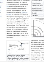
From what i read, shown below, in a perfect world, margin of error for civilian gps can be 16’. Typically accurate only to 50’. I ran compass courses in SAR, we had to be accurate to less than 50’ to be on location.
Even at 16’ margin of error is possible trespassing.
Not arguing, just stating possible down falls of following a blue dot on a screen. Yes, I’ve looked at, thought about OnX but i rarely run into personal private property in mountains.

IMG_1864.jpeg
 
Tthat article is not completely correct. I use a John Deere Starfire gps receiver and I get 6” accuracy and I’m ciivilian 😋 But for general application 16’ seems to be the norm…..
Considering that is a proprietary system, I would expect no less for the cost of receiver and subscription.Doesn’t John Deere also broadcast additional correction information over certain satellites to produce such low tolerance?
 
Not sure. 20 plus years ago i was using a Trimble system and it used coast guard beacon correction signals. I think one was in Spokane and another in Goldendale and we had sub foot accuracy. I use SF2 and it doesn't cost anything, if you use RTK you can get 1" accuracy but pay for it.

From Deere;

The StarFire 7500 Receiver offers a new correction level with accuracy like RTK Radio. The SF-RTK correction level provides 2.5-cm (1-in.) horizontal accuracy without the need for additional hardware. This is an improvement of 17 percent from the previous generation of StarFire receiver with SF3. The SF-RTK signal uses two additional satellite constellations (BeiDou and Galileo) as well as both GPS (United States) and GLONASS (Russia) satellites.

The StarFire 7500 and StarFire 7500 Integrated Receivers simultaneously track correction signals from up to three StarFire correction satellites. The receiver tracks and uses correction signals from all StarFire satellites in view and intelligently chooses one that delivers the best performance. When the receiver moves into an area where the primary StarFire signal is blocked, such as near a tree line, the receiver automatically switches to an alternate StarFire signal (if visible) to help maintain accuracy and performance.
 
I wasn't talking about your GPS location accuracy, I was talking about the accuracy of the parcel data itself. OnX pulls all that property data from county assessor sites, or they pay a company who collects the same data and sells it to them. That data's accuracy varies and is not survey grade.

It's still good enough to use 99% of the time, but something good to keep in mind if you are in a situation of needing to know exactly where a private property line is.
 
Back
Top