Back-Country Route Making back in the day

My backpacking days were like my Father before me, all fishing driven. My timeframe was the decade between 1974-1984.

Starting off with a July 4th trip to a mostly frozen Found lake in 74 up out of Marblemount πŸ€•

Spent quite a bit of time up there with 3 trips to the Found / Snowking system. One regret was not doing the day trip up to Cyclone. I was right at the inlet stream on Found that flowed down off Cyclone catching nice sized cutt/bows. Up that boulder field about 45 minutes & it would have bought me to lakeside.

The Slide Lake to Enjar to Arrowhead to Whale was a good cross-country test of stamana & route finding. Excellent size cutts in Whale in summer of 76. No Golden's thou my old intel showed them planted there in the late 1940's.

The Swallow lake system were always a favorite destination off the Leland lake trail. As were the lakes to the South off the backside of Leland. Shoal was too shallow to be of interest to me, but Jungfrau was quite scenic. Then on to lower & upper Phoebe, the upper lake absolutely gorgeous setting cupped in a mountainside hanging valley. I have Kodachrome slides of it somewhere that showcase the crystalline blue skys against the green trees & reflected blue of the lake like only that film type can pull off. I've told my Son I wouldn't mind my ashes being placed there. It's that kind of a place.

We were planning a traverse from the Swallow system over the Granite mountain potholes then dropping off granite slabs into upper Klonaqua. This was summer of 77. Plan was to exit off French Creek and out that way. I wound up banging up my left knee to the point I could barely make it out of the 1st set of lakes and back to the truck. So that trip was left aborted. Wound up a few years later blowing up that pattela tendon playing volleyball. I'm sure it was related to the original injury.

I have more of those trips, some just planned some actually executed. These are the ones that come to mind this morning.

All this was inspired by the Golden trout traverse thread. So thanks to author for that post

c/22
 
Last edited:
If anyone has done similar trips please chime in. I'm more in the armchair audience now
 
Thru hike I've been wanting to do:
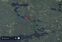
Dingford Trail head up MF Snoqualmie. Side trip to goldmeyer.
Up and over DM Gap, then down to waptus.
Pack raft the lake down to the canyon section of the waptus river, skirt the canyon on foot and then raft the prairie section, then hike out to salmon la sac. ~29 miles, but only 3,800 up and 4800 down. Very doable. Just long.

I'll PM you on a few others.
 
Slide Enjar Whale Arrowhead has been on my list for quite some time now. Would make a terrific adventure.

In high school my boy scout troop took the Lady of the Lake up to Holden and we started hiking and 75 miles later came out in the upper sauk drainage. Caught a really nice fish in Image Lake on that trip.
 
Slide Enjar Whale Arrowhead has been on my list for quite some time now. Would make a terrific adventure.

In high school my boy scout troop took the Lady of the Lake up to Holden and we started hiking and 75 miles later came out in the upper sauk drainage. Caught a really nice fish in Image Lake on that trip.
Ever been up to enjar? It alone is worth a trip.
 
Dave, your mention of Image Lake reminded me of a really beautiful trip my wife and I did some years ago; the Bath Lakes Traverse. It starts out gaining 4500' from the end of the Suiattle River Road over the shoulder of Sulphur Mountain and traverses "Stonehenge Ridge" out to Totem Pass and exits via Image Lake. I caught a very nice Westslope in upper Bath Lake. My pack must have been about 3/4 ton as in addition to the camping gear I was carrying a fly rod, full 50 m climbing rope, an SLR with three lenses and a tripod.
We followed a route detailed in Tabor & Crowder's Routes and Rocks book. Beautiful views S to Glacier Peak along the route, and spectacular wildflowers around Totem Pass. There was some interesting terrain to negotiate, but nothing extreme.
 
While at Enjar & Hamar I was looking hard at that rock wall directly to the East. Up & over that then down the valley would lead a guy to Snowking lake right at the base of the mountain. I had been there previously & the fish in that turquoise colored lake absolutely lacked any fear of man whatsoever. I had decent sized cutt/bows right off my boot tips looking at me....🀷

Instead we went directly North over the ridge and down a huge boulder field into Arrowhead. Really nice campsite right there, then next morning did a contour around to our NNE to Whale. Now that lake is worth the sweat. If a guy humped a raft in you could have your way with the fish. Rugged shoreline on Whale
 
Last edited:
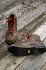
I could never get my old external frame backpack under 45 lbs, 55 was kinda the norm. Was young & stronger than smart for sure. Remember throwing big cans of Dinty Moore beef stew in for dinner, a smallish cast iron skillet for trout. I used to pack in my SLR with a push pull 70-210mm zoom for heavens sake!! Had a nice 3 man REI tent, North Face Cats Meow sleeping bag, Alpinelite knock off backpack. I'd usually grab a pair of those old school Swiss Raichle mountain boots with the red laces REI used to rent out if you can believe that, and snatch up a well used ice axe for good measure. A few token Mountain house freeze dried meals and check out Art Wolfe's artwork on the wall.

Then off to the hills. Blisters be damned
il_794xN.7971873361_kpcs.jpg
 
Last edited:
Did a 3 week backpacking trip NE of Sacramento, where those skiers died last winter, learned how triangulation and find our way with only a compass and greentrails map!
 
While I was still in the service in the mid-1990s we’d (my wife and I) make an annual trip to Lake Kabetogama in Voyguers National Park. We’d haul the bass boat up to the same cabin resort every year to catch smallmouth and pike. The resort owner was from an old family that settled on Lake Kabetogama in the 1950s and he knew where the bast fishing was. One summer during our annual trip he suggested an adventurous day trip to Shoepack Lakeβ€”home of the Shoepack strain of musky. Unfortunately from our location at the resort, a day trip to Shoepack was only possible with a bit of bushwhacking. There was no formal trail to Shoepack from the Eastern end of Lake Kabetogama but over the years, resort owners, completely ignoring NPS rules, blazed and informally marked an unimproved trail to the lake. The NPS maintained a crude backcountry campsite on Little Shoepack Lake along with a canoe that could be used by anyone reaching to the lake. However to get there one had to take a boat to the Northeastern end of Lake Kabetogama, hike about 1 mile north to Lake Jorgens and then bushwhack westward toward Little Shoepack another mile. The mile in between Jorgens and Little Shoepack was pretty much guess work and we’d occassionaly come across a well worn strip of surveyor’s tape to convince use we were on track. Once at Little Shoepack we located the canoe and paddled to the West end of the lake. There a small, but rather steep creek flowed West down to Shoepack Lake. We managed to drag the canoe down OK and were able to fish in Shoepack for several hours connecting with several nice muskies. Once we found the little cove we arrived at, we had to reverse the trip to get home this time dragging the canoe up the steep creek bed. What I remember most about the journey was the utter lack of distinguishing landmarks as we bushwacked between Little Shoepack and Jorgens. A compass really came in handy in the dense scrub and trees. We made it back to the boat on Kabetogama still safely moored and back to the resort by dusk. It was a day to remember not only for the adventure of bushwhacking, but the opportunity to catch a pretty rare fish.
IMG_1204.jpeg
 
Slide Enjar Whale Arrowhead has been on my list for quite some time now. Would make a terrific adventure.

In high school my boy scout troop took the Lady of the Lake up to Holden and we started hiking and 75 miles later came out in the upper sauk drainage. Caught a really nice fish in Image Lake on that trip.
when i was 15, did the 20 (or a day or two more) day North Cascades trip. we started hiking in somewhere up from darrington. we did our 3 day solo just up from holden, then walked down and got group back together, resupplied, ate, and started back. we made a big circle hike - but the year was.... 1970?, and there was still a lot of snow in mid june into july. no fishing. getting over passes was a challenge as the trails were under snow... no idea how many miles. it was something. it was an outward bound trip.
 
Last edited:
Best I did was 11 days in the North Cascades, entered at Marblemount, came out at Steheikin, and hit all the highlights in between. A lot of up and downs, a0n awful lot of scrambles, and a bunch of big lake Cutts, with some river fishing on the way out.
Spent a bunch of time on the upper Queets one fall, camped and hiked upstream as far as we could go, but no alpine treks out of the valley, just fishing.

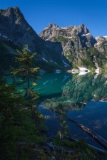
north-cascades-np-30-trapper-lake.jpg
I've been here 3 times, and know that it is highly unlikely I'll be there again, which sort of sucks..
 
Last edited:
Best I did was 11 days in the North Cascades, entered at Marblemount, came out at Steheikin, and hit all the highlights in between. A lot of up and downs, a0n awful lot of scrambles, and a bunch of big lake Cutts, with some river fishing on the way out.
Spent a bunch of time on the upper Queets one fall, camped and hiked upstream as far as we could go, but no alpine treks out of the valley, just fishing.

View attachment 189037
I've been here 3 times, and know that it is highly unlikely I'll be there again, which sort of sucks..
You go over ptarmigan, or up the river?
 
Nosed into Ptarmigan for a couple nights just to see a bit of it, then backtracked to Sahale glacier camp, Horseshoe Basin, Doubtful and scrambles on that side, land then across to Pelton Basin and up and over the ridge to a lake,
Lots of side trips and scrambles then down the valley.
 
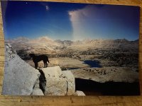
Most of mine were done in the Sierra. 3 bear canisters (me and the best dog ever) eventually broke me. Nothing more rewarding than heading out cross country and hitting your mark. Weather and terrain often changed the original plan.
Tom Harrison maps and a compass, landmarks are pretty easy above tree line, but contours dictate the route. Some of my best memories
IMG_6157.jpeg
 
Back
Top