App for locating overstocked lakes

field.cady

Just Hatched
Hi everybody,
A couple years ago I made a web app for locating overstocked and/or alpine lakes in Washington state. The DOFW already publishes a list of lakes, but it's just a bunch of text listed in alphabetical order. I put allof them on a map so you can tell what's near you and plan a fishing trip. Hope this helps some people! Please LMK if you have suggestions for improvements. Take care everybody!
 
Does overstocked mean stunted population, they just put too many fish in, or dropped from aircraft?
 
Does overstocked mean stunted population, they just put too many fish in, or dropped from aircraft?
From WDFW:

Overabundant fish lakes​

Brook trout, cutthroat and some strains of rainbow are adaptable and prolific in their spawning habits, sometimes using springs to spawn in high lakes. Uncontrolled reproduction in high lakes can lead to overpopulation. Such trout lakes are characterized by dense populations of slow growing trout with large heads and skinny bodies. Essentially, they are eating themselves out of house and home.
WDFW allows for a more liberal harvest in some of these over-populated lakes and stocks others with predator species to bring these populations under control. The agency encourages anglers to fish these lakes and has identified where over-populated lakes exist through the high lakes mapping tools. Anglers are strongly encouraged to seek out these lakes and remove the legal number of trout each day they fish. Reducing the over-abundance of trout in these lakes lessens the impact these populations are having on lake ecology and native aquatic fauna.
 
Hi everybody,
A couple years ago I made a web app for locating overstocked and/or alpine lakes in Washington state. The DOFW already publishes a list of lakes, but it's just a bunch of text listed in alphabetical order. I put allof them on a map so you can tell what's near you and plan a fishing trip. Hope this helps some people! Please LMK if you have suggestions for improvements. Take care everybody!
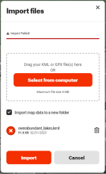
This is really cool, thanks for sharing. Any idea why the .kml files will import to Earth, but not OnX?
 
.KML is native to Google Earth. You might be able to open/save it in GE and then export it in some format that OnX can handle.
 
.KML is native to Google Earth. You might be able to open/save it in GE and then export it in some format that OnX can handle.
This is really cool, thanks for sharing. Any idea why the .kml files will import to Earth, but not OnX?
Yes. To use them in our ESRI platform they have to be imported converting to a SHP file. Everyone has their own idea on the best way to store georeferenced data.
Some of our handheld utilities such as farmworks do not have the import/convent function built in, but it usually resides in the desktop support platform. A quick search for OnX I found this: https://onxmapssupport.zendesk.com/...ypoints-Lines-Shapes-and-Tracks-with-onX-Hunt
 
  • Like
Reactions: Zak
.KML is native to Google Earth. You might be able to open/save it in GE and then export it in some format that OnX can handle.
Yes. To use them in our ESRI platform they have to be imported converting to a SHP file. Everyone has their own idea on the best way to store georeferenced data.
Some of our handheld utilities such as farmworks do not have the import/convent function built in, but it usually resides in the desktop support platform. A quick search for OnX I found this: https://onxmapssupport.zendesk.com/...ypoints-Lines-Shapes-and-Tracks-with-onX-Hunt
It's weird, OnX says to use .kml files. For some reason it just doesn't work. 🤷‍♂️
No biggie, having these in GE is still freaking awesome.

1675354618495.png
 
  • Like
Reactions: Zak
Back
Top