

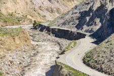
As I was going through YNP photos on the flooding, several things stood out to me. One the flooding in the narrow Gardner River canyon did indeed do a lot of damage to the road but didn't alter the water course much and there wasn't much vegetation in that section to wash away anyway. When normal flows return, the newly exposed areas should revegetate quickly.
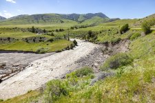
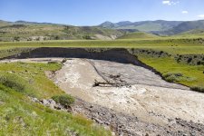
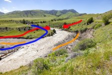
The following two photos show the section of the Gardner just adjacent to the North gate. It looks like a lot of change, but I think that knowing what it looked like before is instructive. Although there appears to be a lot of washout, the river course didn't change.
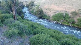
I didn't have a specific pre-flood image of the above section but have passed through it dozens of times. The photo below (2021 spring) is just below the above section. Note the stream side vegetation. Pretty typical of what was there (although not as thick in the washout areas) prior to the flood.
I took the two flood photos above and annotated them with some lines to show what we've lost (and haven't) lost.
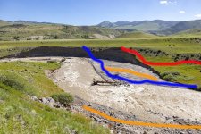
The section was a low gradient, shallow section (by comparison to stretches above and below it). It never held many decent fish. The BLUE line was the route of an angler trail off the bench down to the river.
The ORANGE line represents areas of scattered low brush that made this stretch easy to fish for anglers walking down from the road above. The RED line represents an old wagon roadbed built by the army to access their firing range on the bench. In the image below, the two RED dots represent the rock bridge abutments built by the army. It appears they are still intact and there was no catastrophe damage upstream from the abutments until you reach the Rescue Creek trailhead bridge.
Apart from a lot of rocks having been moved around and some streamside vegetation washed away, it appears the flood didn't do that much damage to the natural aspects of the river, especially in the narrow canyons. When the waters recede, we'll see more of what's been moved about. In the Spring, this section of the river downstream from the rescue creek trailhead gets a big flush of fish from the Yellowstone chasing Salmon flies. That might not happen this year and most likely we won't get much opportunity to find out anyway. During summer low water, small resident browns predominate. In the Fall however, big browns enter the river from the Yellowstone to spawn. Apart from the infrastructure issues, I suspect the Gardner will be back to its old self in 2023 although maybe not as scenic in some places.
The following two photos show the section of the Gardner just adjacent to the North gate. It looks like a lot of change, but I think that knowing what it looked like before is instructive. Although there appears to be a lot of washout, the river course didn't change.
I didn't have a specific pre-flood image of the above section but have passed through it dozens of times. The photo below (2021 spring) is just below the above section. Note the stream side vegetation. Pretty typical of what was there (although not as thick in the washout areas) prior to the flood.
I took the two flood photos above and annotated them with some lines to show what we've lost (and haven't) lost.
The section was a low gradient, shallow section (by comparison to stretches above and below it). It never held many decent fish. The BLUE line was the route of an angler trail off the bench down to the river.
The ORANGE line represents areas of scattered low brush that made this stretch easy to fish for anglers walking down from the road above. The RED line represents an old wagon roadbed built by the army to access their firing range on the bench. In the image below, the two RED dots represent the rock bridge abutments built by the army. It appears they are still intact and there was no catastrophe damage upstream from the abutments until you reach the Rescue Creek trailhead bridge.
Apart from a lot of rocks having been moved around and some streamside vegetation washed away, it appears the flood didn't do that much damage to the natural aspects of the river, especially in the narrow canyons. When the waters recede, we'll see more of what's been moved about. In the Spring, this section of the river downstream from the rescue creek trailhead gets a big flush of fish from the Yellowstone chasing Salmon flies. That might not happen this year and most likely we won't get much opportunity to find out anyway. During summer low water, small resident browns predominate. In the Fall however, big browns enter the river from the Yellowstone to spawn. Apart from the infrastructure issues, I suspect the Gardner will be back to its old self in 2023 although maybe not as scenic in some places.


