Topo maps for lakes?

Bass-O-Matic

Life of the Party
I remember seeing many useful lake topo maps on a website I thought was called Washington Lakes but can seem to find that these days? Does anybody know of a good resource for such info? If my memory is correct they even had some reports though often not up to date but of some value for a historical perspective. Maybe this would be a "app thing" at this point in time?
Thanks
 

RCF

Life of the Party

That thread has other links also... Hope it helps...
 

PhilR

IDK Man
Forum Supporter
The atlas of oregon lakes has it for Oregon
 

Old406Kid

Life of the Party
Forum Supporter
The site I think you’re looking for is northwestfishingreports.com then click maps.
The maps and reports are definitely a wealth of information for free.
 

Brian Miller

Be vewy vewy quiet, I'm hunting Cutthwoat Twout
Forum Supporter
The site I think you’re looking for is northwestfishingreports.com then click maps.
Recommend saving your own copies of the ones you want.
If you're referring to www.northwestfishingreports.com, No Kidding! Saving *as jpg files* locally to your device not only allows use in the field out of cell coverage, the number of pop-up ads on the NWFR site if your browser doesn't block them is abjectly horrible. My ad blocker reports blocking 37 popup ads on that site, and I find it unusable on a device without an ad blocker installed.
Oh, and if you don't like spam, don't create an account on NWFR.
 
Last edited:

Brian Miller

Be vewy vewy quiet, I'm hunting Cutthwoat Twout
Forum Supporter
Last edited:

Divad

Whitefish
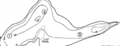
My favorite lakes are the ones barely documented for depth. Usually it requires scouring the internet for old maps like this:

2F9BD7DF-AB01-4F03-A8E6-0A3D9904C388.jpeg
I absolutely love the process and history involved for those hidden gems and hope nobody aggregates them into a db.

But the site Billy notes is my favorite when available, I save a lot of those before a trip.
 

Billy

Big poppa
Staff member
Admin
It doesn't seem to include the obvious non-motorized and selective/FF only/CR lakes I prefer for a float tube or WM, probably because it's a navigation app.
It isn't really just a navigation app. You can shade depth contours, adjust water levels etc with appropriate fish finders/gps plotters. Pretty tremendous resource. Of course it won't have all the small hike in ponds. I was surprised to see Grimes Lake on it. Most of the lake chips are growing in the amount of lakes🍻
 

Brian Miller

Be vewy vewy quiet, I'm hunting Cutthwoat Twout
Forum Supporter
It isn't really just a navigation app. You can shade depth contours, adjust water levels etc with appropriate fish finders/gps plotters. Pretty tremendous resource. Of course it won't have all the small hike in ponds. I was surprised to see Grimes Lake on it. Most of the lake chips are growing in the amount of lakes🍻
Thanks, Yes I am incorrect putting it into a navigation and internal combustion motors allowed box. Looking beyond lakes I often fish, it does contain Rattlesnake & Pass, and other no-motor lakes, but not Cady, Coldwater...

How are lakes added to the catalog?
Is it possible to upload lake contour data to Garmin and other fish finders with mapping capabilities?
 
I remember seeing many useful lake topo maps on a website I thought was called Washington Lakes but can seem to find that these days? Does anybody know of a good resource for such info? If my memory is correct they even had some reports though often not up to date but of some value for a historical perspective. Maybe this would be a "app thing" at this point in time?
Thanks

BC also has a great resource for bathymetric maps...1950s era maps for some of the lakes I fish up there.

 
Top