
This subject has probably been covered many times but I can't find what I want in the search portion. What is a good app for Apple phones that identifies land boundaries?

Follow along with the video below to see how to install our site as a web app on your home screen.
Note: This feature may not be available in some browsers.


100% - this app is both amazing and kind of a bummer. Amazing for selfish reasons... a bummer that it gives folks a way to find ways in to secret squirrel spots (both fishing and hunting).


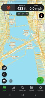
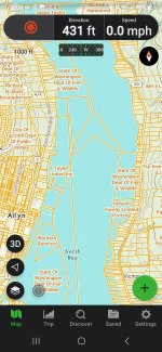
Here's what Gaia showsDo any of these show private vs public tidelands on Washington beaches?

 troutroutes.com
 &
&  sure has a fly fi$$$hing price tag compared to Gaia ($40 worldwide) & OnX (1 State $30 - 2 State $45) that can be used with other apps like RiverFlows, GoPaddling, and FishWA (yeah I know, works for me)...
Here's what Gaia shows
View attachment 77148 View attachment 77149
*Oh, and Gaia is available on Apple & Android
On that note, I’ve often wondered how the actual landowners of the public lands that are left (that would be us) that have been leased out to private enterprises (like Taylor Shellfish, etc.), can’t have access for limited recreation (like fishing).It really sucks that the state ever sold or allowed any tidelands to be sold.
SF
Same goes for public land that has had roads gated - bermed & trenched, perhaps due to lack of will and budget to clean up after "long term campers" and other slobs that leave their garbage, spent shotgun shells, shattered clays, shot up cans & bottles, trees cut & shot up...On that note, I’ve often wondered how the actual landowners of the public lands that are left (that would be us) that have been leased out to private enterprises (like Taylor Shellfish, etc.), can’t have access for limited recreation (like fishing).


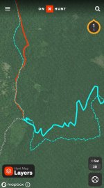
I love OnX as well.....but....it leaves a bit to be desired with the accuracy of the trails it shows on map. Several times I've checked OnX and the location it shows me is not very near where the OnX map shows the trail, even though I was physically on the trail.100% - this app is both amazing and kind of a bummer. Amazing for selfish reasons... a bummer that it gives folks a way to find ways in to secret squirrel spots (both fishing and hunting).
On that note, I’ve often wondered how the actual landowners of the public lands that are left (that would be us) that have been leased out to private enterprises (like Taylor Shellfish, etc.), can’t have access for limited recreation (like fishing).